

Colorado Hail Storm Report, June 30, 2026: Radar Estimated Hail Over 2.75 Inches Along the South Platte Near Iliff and Crook
August 16, 2026
By Red Hawk Roofing
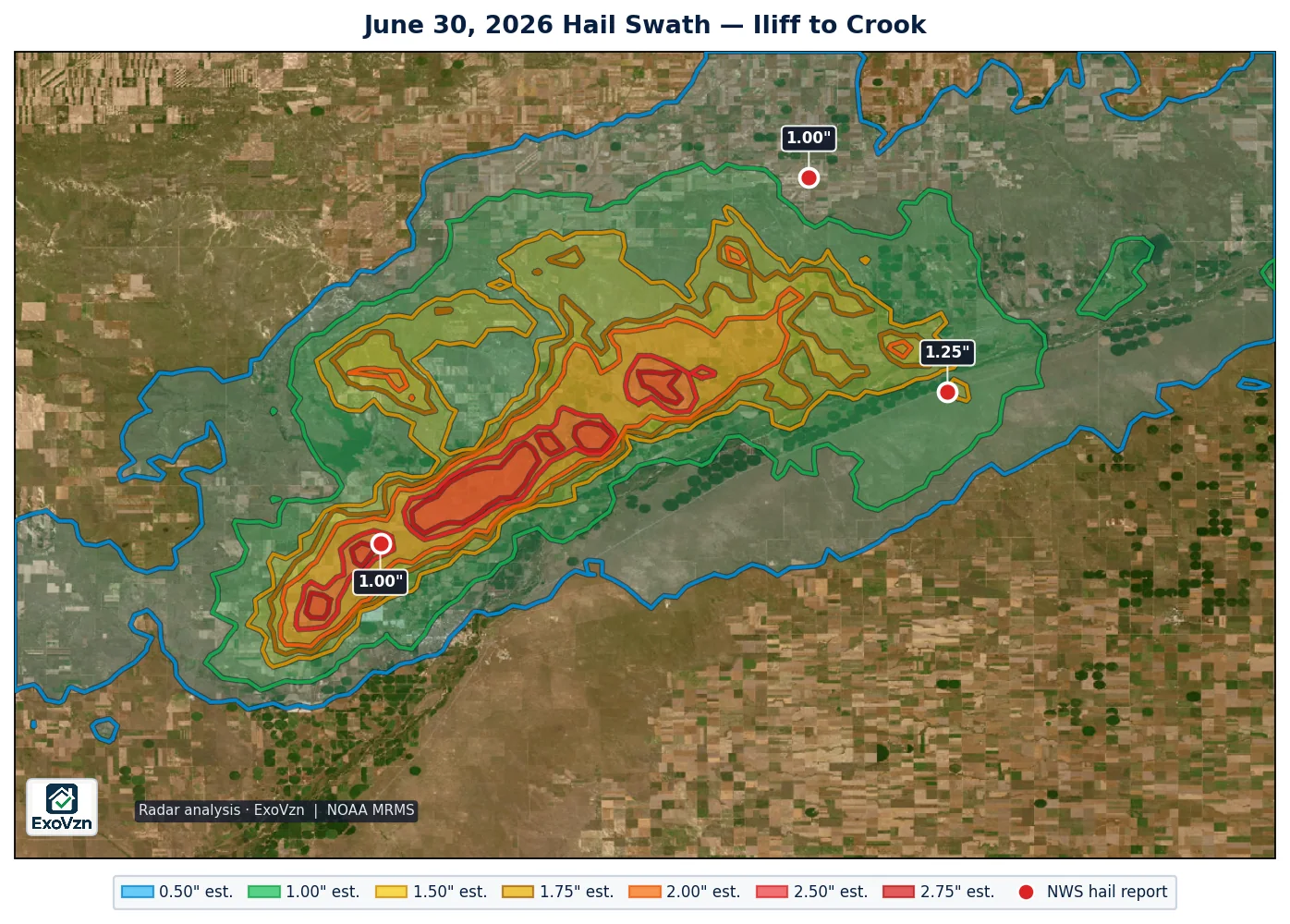
On the evening of June 30, 2026, a tornado-warned storm ran down the South Platte valley northeast of Sterling with radar-estimated hail cores above 2.75 inches — the estimated 2.00 inch contour sat directly over Proctor — while the largest hail anyone reported on the ground was 1.25 inches. That gap is the story of this report.
The Iliff and Crook hail map — June 30, 2026
What was reported on the ground
These are the only hail reports on the corridor that evening. Measured means an observer put a ruler or gauge on the stone; reported means a size category was selected. Times are MDT.
| Location | Size | Time | Source | Basis |
|---|---|---|---|---|
| 3 S Crook | 1.25" | 8:16 PM | Public | reported |
| 6 S North Sterling Reservoir | 1.00" | 7:45 PM | Trained Spotter | reported |
| 10 NW Twin Buttes | 1.00" | 8:21 PM | Storm Chaser | measured |
What radar estimated over the corridor
All figures below are radar estimates — MRMS output, not measurements. The convective-day analysis puts about 687 square miles of Colorado under estimated 1.00 inch or larger hail that day, with 96 square miles under estimated 2.00 inch or larger and about 16 square miles under estimated 2.75 inch or larger — nearly all of it in one swath train along the South Platte from northwest of Sterling through Iliff and Proctor toward Crook.
- Proctor sits inside the estimated 2.00 inch contour, six-tenths of a mile from the estimated 2.50 inch core.
- Iliff sits inside the estimated 1.00 inch swath, a mile from the 1.75 inch contour and under two miles from an estimated 2.75 inch core.
- Crook sits inside the estimated 1.00 inch swath, seven-tenths of a mile from the 1.50 inch contour.
- Sterling sat just outside the swath — about a mile from the 1.00 inch contour, four to six miles from the big cores.
On this corridor? Radar is a reason to look. We'll come look, free.
Schedule My Free Inspectionor call (720) 771-8921
Why the gap between radar and reports
A hail report only exists when someone finds the stones and files a report. This storm crossed sparsely populated river-bottom ranchland at dusk, under a tornado warning — the three reports that exist were filed from the couple of roads with people on them, while the estimated cores tracked the empty ground between. The absence of further reports is not evidence that hail did not fall.
The honest cut goes both ways: radar hail output is a deliberate high-end estimate of what may exist inside the storm, and it can overestimate what actually lands. Never treat an estimated 2.75 inch core as proof that 2.75 inch hail fell near Iliff — and never treat three small reports as proof that it did not. Treat the swath as the search area; a physical inspection is the only thing that settles a specific address.
The storm was warned, start to finish
A severe thunderstorm warning covered the corridor from 6:51 PM — 54 minutes before the first hail report — followed by warnings at 7:32 and 8:10 PM, a tornado warning from 7:49 to 8:24 PM covering the 8:16 PM Crook hail, and a second tornado warning from 8:22 to 8:38 PM. Two tornadoes were reported, east of North Sterling Reservoir at 7:40 PM and east of Sterling at 7:46 PM. A personal weather station near Iliff recorded a 74 mph gust at 7:54 PM.
Frequently asked questions
Was there hail near Iliff and Crook on June 30, 2026?
Radar estimated a train of hail cores along the South Platte valley northeast of Sterling — including cores above 2.75 inches estimated — with the estimated 2.00 inch contour sitting directly over Proctor and both Iliff and Crook inside the estimated 1.00 inch swath. On the ground, spotters and an mPING report caught 1.00 to 1.25 inch hail at the edges of the storm — the only three reports on a 30-mile corridor of ranchland.
Why did radar show much bigger hail than anyone reported?
Two honest reasons. A hail report only exists when someone finds the stones and files it — this tornado-warned storm crossed sparsely populated river-bottom ranchland at dusk, and the three reports came from the couple of roads with people on them. And radar hail output is a deliberate high-end estimate of what may exist inside the storm, which can run above what lands. Both things are true; only an inspection settles what happened at a specific address.
Were there tornadoes near Sterling on June 30, 2026?
Two tornadoes were reported — east of North Sterling Reservoir at 7:40 PM and five miles east of Sterling at 7:46 PM. A tornado warning covered the corridor from 7:49 to 8:24 PM, with a second from 8:22 to 8:38 PM.
How strong was the wind with this storm?
A personal weather station near Iliff recorded a 74 mph gust at 7:54 PM, another southwest of Fleming recorded 67 mph, and a station near Ovid in Sedgwick County recorded 72 mph as the storm crossed into the far corner of the state. Those are home-station instrument readings, not NWS measurements.
Should I get my property inspected if I am on this corridor?
If your buildings sit between Sterling, Iliff, Proctor and Crook, yes — as a reason to look, not as proof of damage. Radar-only evidence means the honest next step is a physical inspection, which costs nothing and documents the condition either way.
This is the second radar-only case of the season — the first was July 29 over the Bennett and Strasburg corridor. Red Hawk tracks every significant hail day across Colorado — see the 2026 season archive. Before any adjuster visit, read what hail damage actually looks like on a roof and the Colorado hail claim guide, or see our hail damage service for what an inspection covers.
Red Hawk works Colorado roofs year round. We'll still be here next season.
Schedule My Free Inspectionor call (720) 771-8921
Storm figures are National Weather Service Local Storm Reports for Colorado on June 30, 2026, retrieved from the Iowa Environmental Mesonet archive; warning times are from the NWS watch/warning archive. Times are MDT and reports are grouped by the local calendar day. Radar swath analysis by ExoVzn, an independent forensic meteorology firm, using NOAA MRMS data. All radar figures are estimates. Storm reports and radar analysis indicate where hail may have occurred; only a physical inspection establishes whether a specific roof or structure was damaged.