

Colorado Hail Storm Report, July 29, 2026: Radar Tracked Hail Over Bennett and Strasburg That Nobody Reported
August 16, 2026
By Red Hawk Roofing
On July 29, 2026, radar tracked a storm dropping estimated 1.00 inch or larger hail across roughly 22 square miles north of Bennett and Strasburg — under two severe thunderstorm warnings — and not one hail report was ever filed. This is what a reporting gap looks like, and why an empty report log does not mean an undamaged roof.
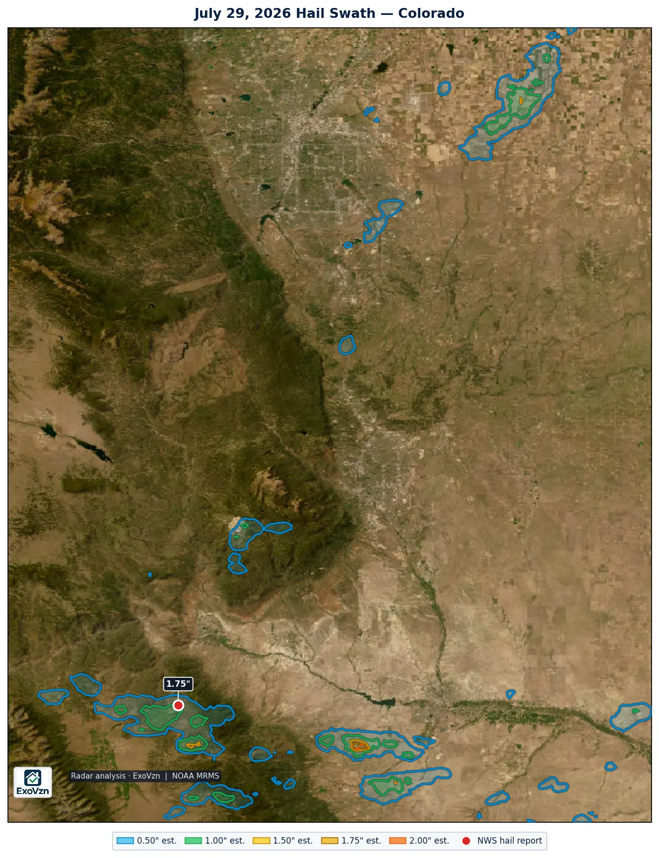
The Colorado hail map — July 29, 2026
The one report that exists
Colorado produced exactly one official hail report on July 29. Times are MDT.
| Location | Size | Time | Source | Basis |
|---|---|---|---|---|
| 11 N Rosita | 1.75" | 6:03 PM | Public | measured |
That measured 1.75 inch stone fell in the Wet Mountains of Custer County — on the one cell that happened to cross a road with an observer on it. It is the ground-truth anchor for the day: the same storm complex the radar was tracking produced real, measured, golf-ball-class hail where somebody was standing.
What radar saw where nobody was standing
All figures below are radar estimates — MRMS output, not measurements.
- North of Bennett and Strasburg (afternoon): an estimated 1.00 inch or larger core covering about 22 square miles, centered roughly 5 miles north of Bennett, inside a broader 107-square-mile footprint of estimated 0.50 inch or larger hail over the I-70 corridor north of both towns.
- The foothills southwest of Pueblo, between Beulah and Lake Pueblo (evening): estimated cores of 1.50 inch or larger over about 3.8 square miles and 1.75 inch or larger over about 1.8 square miles — sparsely populated ranchland.
- Near Colorado City and Rye: an estimated 1.00 inch or larger core of about 9 square miles.
The warnings line up with the radar. NWS Denver/Boulder put two severe thunderstorm warnings on the Bennett-corridor cell, 3:37 to 4:15 PM and 3:56 to 4:45 PM. NWS Pueblo ran four consecutive severe thunderstorm warnings over the foothills southwest of Pueblo from 6:02 to 8:00 PM, plus flash flood warnings from 5:47 PM. Warned storms, radar hail cores, zero reports.
Why nobody reported it
A hail report only exists when someone finds the stones and files a report with the National Weather Service. North of Bennett the storm crossed ranchland and I-70 frontage in the middle of a work afternoon, and no report was ever filed. Southwest of Pueblo the storm crossed foothills country with almost nobody under it. The absence of a report is not evidence that hail did not fall — the radar signature, and the severe thunderstorm warnings on those cells, say otherwise.
Radar-estimated hail is not measured hail
The honest cut goes both ways. Radar hail algorithms output a deliberate high-end estimate of what may exist inside a storm cloud, not a measurement of what landed on your roof — radar estimates characteristically run above what observers actually recover. So treat the swaths on this map as the search area, not as proof of damage. If your property sits inside one, the next step is not a claim; it is an inspection.
What to do if you were under it
- Check from the ground, not the roof. Walking a hail-struck roof is how people get hurt.
- Look in your gutters. Granules washing off in quantity is the most common early sign.
- Check soft metal. Roof vents, gutters, flashing, the mailbox, AC condenser fins. Dents in soft metal date the storm.
- Photograph what you find with your phone. Phone photos carry a timestamp. Do not edit them.
- Get it inspected. Especially if this storm was weeks ago — that is exactly when bruising starts to surface.
Frequently asked questions
Was there hail near Bennett on July 29, 2026?
Radar estimated a core of 1.00 inch or larger hail covering about 22 square miles centered roughly 5 miles north of Bennett, and NWS Denver/Boulder issued two severe thunderstorm warnings on that cell between 3:37 and 4:45 PM. No ground report was ever filed. The absence of a report is not evidence that hail did not fall.
How big was the hail on July 29, 2026 in Colorado?
The only measured stone in Colorado that day was 1.75 inches, 11 miles north of Rosita in the Wet Mountains at 6:03 PM. Everywhere else the evidence is radar: an estimated 1.00 inch or larger core north of Bennett and Strasburg, and estimated 1.50 to 1.75 inch or larger cores in the rural foothills southwest of Pueblo, between Beulah and Lake Pueblo.
Why are there no hail reports if radar showed hail?
A hail report only exists when someone finds the stones and files a report with the National Weather Service. North of Bennett the storm crossed ranchland and I-70 frontage in the middle of a work afternoon; southwest of Pueblo it crossed sparsely populated foothills. Radar signatures and severe thunderstorm warnings say the storms were real — nobody was positioned to file a report.
Can radar-only evidence justify a roof inspection?
Yes — as a reason to look, not as proof of damage. Radar output is a deliberate high-end estimate of what may exist inside the storm, not a measurement of what landed. If your property sits inside a radar swath, the honest next step is a physical inspection, which is the only thing that establishes whether your specific roof was damaged.
Could my roof still have damage from this storm?
Yes. Hail bruising fractures the shingle mat beneath a surface that still looks intact, and the bruised area sheds granules over the following months. Damage from a storm earlier in the season is often only becoming visible now, which is exactly why it is worth checking.
Red Hawk tracks every hail day across the Front Range. See our other storm reports for the rest of the 2026 season.
City-by-city hail histories
Not sure what to look for? Start with what hail damage looks like on a roof and the Colorado hail claim guide.
Red Hawk works Colorado roofs year round. We'll still be here next season.
Schedule My Free Inspectionor call (720) 771-8921
Storm figures are National Weather Service Local Storm Reports for Colorado on July 29, 2026, retrieved from the Iowa Environmental Mesonet archive; warning times are from the NWS watch/warning archive. Radar swath analysis by ExoVzn, an independent forensic meteorology firm, using NOAA MRMS data. All radar figures are estimates. Storm reports and radar analysis indicate where hail may have occurred; only a physical inspection establishes whether a specific roof was damaged.