

Englewood Hail Storm, August 14, 2026: The Middle Day of Three in a Row
August 16, 2026
By Red Hawk Roofing
Updated August 27, 2026 with complete verified storm reports.
The Denver metro took hail three days running in mid-August 2026, and August 14 was the middle day. A 1.00 inch hailstone was measured in Englewood at 3:05 PM, radar estimated a core of 1.50-inch-plus hail just west over the Sheridan corridor, and the same storm put several inches of standing water on Englewood streets within the hour.
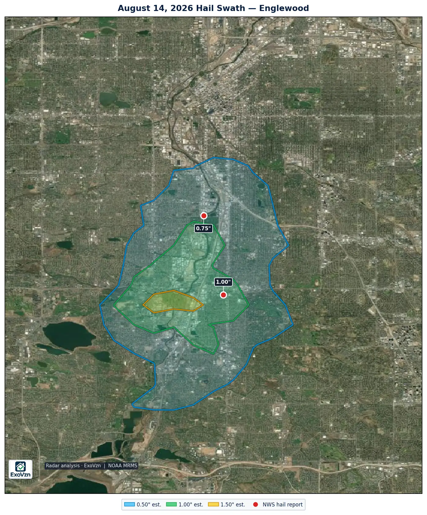
The Englewood hail map — August 14, 2026
What was reported in Englewood
These are National Weather Service Local Storm Reports. Measured means an observer put a ruler or gauge on the stone; reported means a size category was selected. Times are MDT.
| Location | Size | Time | Source | Basis |
|---|---|---|---|---|
| Englewood | 1.00" | 3:05 PM | Public | measured |
| 3 N Englewood | 0.75" | 3:26 PM | Public | reported |
Two official reports — one measured, one reported — both on the Englewood axis, and and this time the ground record and the radar agree the footprint was compact: roughly 8.7 square miles of radar-estimated 1.00 inch or larger hail in the south-metro window, running from about Evans Avenue south toward Littleton. The strongest radar signature, an estimated 1.50-inch-plus core covering under a square mile, sat about a mile west of Englewood. That is a radar estimate, not a measurement; the measured stone in Englewood was 1.00 inch.
The same storm flooded streets as the hail ended. Broadcast media reported several inches of standing water a mile northwest of Englewood at 3:55 PM, and street flooding was reported at Belleview and Broadway at 4:03 PM. A flash flood warning ran from 2:57 PM to 6:00 PM.
Was a warning issued for Englewood?
Yes. NWS Denver/Boulder issued a severe thunderstorm warning covering Englewood at 2:49 PM — 16 minutes before the 3:05 PM measured hail — with further severe thunderstorm warnings at 3:09 PM and 3:36 PM as storms continued over the metro.
Three hail days in a row
August 14 did not happen in isolation. The afternoon before, ground-measured hail up to 1.75 inches raked Centennial, Foxfield and Arapahoe Park. The afternoon after, radar tracked two cores of 1.00 to 1.96 inch estimated hail over Ken Caryl, Morrison, Lone Tree and Parker. A roof in the south metro could have been hit on any of the three days — or more than once.
Why a 1.00 inch measured stone matters
Published impact studies put the onset of functional damage near 1.00 inch for standard three-tab asphalt shingles — exactly the size measured in Englewood — with 1.25 inches for architectural shingles and 2.00 inches for Class 4 impact-rated products. Hail bruises a shingle by fracturing the mat beneath a surface that still looks intact, and the bruised area sheds its protective granules over the following months. Roof age matters too: shingles already weathered by earlier storms are far more susceptible in the next one.
How to check your roof
From the ground — never climb up:
- Granules collecting in gutters and at downspout outlets
- Dents in soft metal — roof vents, gutters, flashing, the mailbox, AC condenser fins
- Splatter marks on decking, fascia or fence tops
- Any new interior staining after the flooding rain that followed the hail
Englewood is part of Red Hawk’s core service area — our headquarters is on South Platte River Drive, inside this storm’s footprint. See the Englewood roofing page for the city’s full documented hail history, and our hail damage service for what an inspection covers. Before the adjuster visit, read what hail damage actually looks like on a roof and the Colorado hail claim guide.
Radar estimate and ground reports by city — August 14, 2026
The map above is the search area. This table asks two narrower questions for each Red Hawk service-area city: did any NWS ground report come from inside the city’s actual boundary, whatever locality name the NWS filed it under; and did a radar-estimated hail band of 1.00 inch or larger cross that boundary? A ground report is an observation and always lists the city. The band is an MRMS estimate, not a measurement.
| City | Radar estimate | Share of the city under it | Ground reports inside it | Boundary used |
|---|---|---|---|---|
| Sheridan | 1.50" est. | 33% (east part) | none | city limits |
| Englewood | 1.50" est. | <1% (west part) | 1 report, 1.00″ (measured) | city limits |
| Denver | 1.00" est. | 2% (southwest part) | 1 report, 0.75″ (reported) | city limits |
Radar estimated hail to 1.50 inches over part of Sheridan (about 33 percent of it, in its east part). No ground observer reported from Sheridan that day — reports come from where people happen to be, and their absence is not evidence that nothing fell.
Radar estimated hail to 1.50 inches over part of Englewood (less than 1 percent of it, in its west part); the 1.00 inch band covered about 56 percent of it. On the ground, one National Weather Service hail report came from inside the Englewood city limits: 1.00 inch (measured). One more report naming Englewood (“3 N Englewood”) came from outside that boundary.
Radar estimated hail to 1.00 inch over part of Denver (about 2 percent of it, in its southwest part). On the ground, one National Weather Service hail report came from inside the Denver city limits: 0.75 inches (reported). That report was logged by the NWS under the locality name “3 N Englewood”.
City boundaries are the U.S. Census Bureau TIGER/Line 2025 place limits; Denver neighborhoods use the City and County of Denver’s statistical neighborhood polygons. A city is listed if any NWS ground report came from inside that boundary, or if a 1.00 inch or larger radar band crosses it; a ground report is never left off for the size of the radar estimate. The 0.50 inch band also crossed 14 other service-area cities with no ground report inside them; those are not listed because hail under one inch rarely damages asphalt shingles and a radar band that small is an estimate below that threshold. A band at or above 1.00 inch also clipped the edge of 2 further service-area cities without a ground report inside them, by less than one radar grid cell of area. Those are not listed: MRMS is gridded at about one kilometre and the swath it draws is displaced from where the stones landed, so an overlap that small does not establish that hail fell in the city. Bands over cities more than 10 miles from this storm’s own reports belong to other storms on the same day and are not listed here.
Hail duration, warnings and wind
The same system produced 10 Colorado wind reports that day, the strongest 64 mph at 9 NNE Kiowa. Wind damage and hail damage look different on a roof and are assessed separately.
CoCoRaHS volunteer observers logged 7 Colorado hail observations on this date, the longest running 15 minutes at Castle Rock 1.7 E. That network records how long hail fell and what it damaged, which NWS storm reports do not capture.
Frequently asked questions
Was there hail in Englewood on August 14, 2026?
Yes. A 1.00 inch hailstone was measured in Englewood at 3:05 PM MDT on August 14, 2026, and a 0.75 inch stone was reported three miles north at 3:26 PM. A severe thunderstorm warning covering Englewood had been issued at 2:49 PM — 16 minutes before the first measured hail.
How big was the hail in Englewood?
The largest measured stone was 1.00 inch, in Englewood itself. Radar estimated a core of 1.50-inch-plus hail about a mile west of Englewood, over the Sheridan and river corridor — that is a radar estimate, not a measurement. A hail report names the largest stone an observer found, not what fell across the whole city.
Did it hail in the Denver metro three days in a row in August 2026?
Yes. Southern Arapahoe County took ground-measured hail up to 1.75 inches on August 13, Englewood took measured 1.00 inch hail on August 14, and radar tracked two cores of 1.00 to 1.96 inch estimated hail over the south metro on August 15.
My neighbor's roof looks fine. Does that mean mine is?
Not necessarily. This storm's footprint was compact — roughly 8.7 square miles of radar-estimated 1.00 inch or larger hail, centered on the Englewood and Sheridan area. A home a mile off that footprint may have seen little more than heavy rain. Damage varies street by street.
Should I get my Englewood roof inspected after this storm?
If your address is in or near the swath, yes. A 1.00 inch measured stone is at the published functional-damage onset for standard three-tab shingles, and hail bruising is commonly invisible from the ground for months. An inspection costs nothing and documents the roof's condition either way.
Were there damaging winds in Colorado on August 14, 2026?
Yes. The National Weather Service logged 10 wind reports in Colorado on August 14, 2026, the strongest 64 mph at 9 NNE Kiowa. Wind and hail damage a roof differently — wind lifts and creases shingles along edges and ridges, hail bruises the field.
How long did hail fall in Colorado on August 14, 2026?
CoCoRaHS volunteer observers — a trained precipitation network separate from NWS storm spotters — logged 7 hail observations in Colorado on August 14, 2026. The longest was 15 minutes at Castle Rock 1.7 E. CoCoRaHS reports carry duration and damage notes that an NWS report does not.
Was there hail in Sheridan on August 14, 2026?
Radar estimated hail to 1.50 inches over part of Sheridan (about 33 percent of it, in its east part). No ground observer reported from Sheridan that day — reports come from where people happen to be, and their absence is not evidence that nothing fell.
Was there hail in Denver on August 14, 2026?
Radar estimated hail to 1.00 inch over part of Denver (about 2 percent of it, in its southwest part). On the ground, one National Weather Service hail report came from inside the Denver city limits: 0.75 inches (reported). That report was logged by the NWS under the locality name “3 N Englewood”.
Red Hawk tracks every hail day across the Front Range. See our other storm reports for the rest of the 2026 season.
Red Hawk works Colorado roofs year round. We'll still be here next season.
Schedule My Free Inspectionor call (720) 771-8921
Storm figures are National Weather Service Local Storm Reports for Colorado, 12Z August 14 through 12Z August 15, 2026, retrieved from the Iowa Environmental Mesonet archive and de-duplicated; warning times are from the NWS watch/warning archive. Radar swath analysis by ExoVzn, an independent forensic meteorology firm, using NOAA MRMS data. Radar figures are estimates. Storm reports indicate where hail occurred; only a physical inspection establishes whether a specific roof was damaged.