

Colorado Wind Storm Report, September 8, 2026: Pueblo
September 8, 2026
By Red Hawk Roofing
Updated September 23, 2026 with complete verified storm reports.
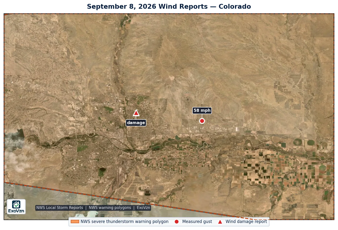
Thunderstorm winds measured to 58 mph hit Pueblo on September 8, 2026. The National Weather Service has logged 2 wind reports in this storm’s footprint for that date, including 1 damage report.
Where the Colorado wind reports came from — September 8, 2026
Every wind report in this storm
These are National Weather Service Local Storm Reports — wind an instrument measured or an observer reported, not a radar estimate. Times are MDT. “Measured” means an anemometer reading the NWS flagged as measured (an airport, mesonet or personal weather station); “estimated” means an observer’s estimate; “damage” means the NWS logged what the wind broke, with no speed attached. Speeds are as issued by the NWS.
| Location | Wind | Time | Source | Basis | Details |
|---|---|---|---|---|---|
| 5 NE Blende | 58 mph | 7:09 PM | Official NWS Obs | measured | Peak wind at the Pueblo Memorial Airport. |
| 2 E Pueblo | damage | 6:53 PM | Public | damage | Branches up to 1.5 inches in diameter came down in the Belmont neighborhood which also broke the windshield of a van. Report relayed by broadcast media. |
By location: 5 NE Blende (5.9 mi from Pueblo); 2 E Pueblo (Pueblo). An NWS wind report names the nearest place the observer or station reported from, not everywhere the wind blew.
Was your address in this one? We'll come look, free.
Schedule My Free Inspectionor call (720) 771-8921
What the NWS warned for, and what was measured
The National Weather Service issued 1 severe thunderstorm warning covering the reports in the table, the first at 6:57 PM MDT, warning for winds to 60 mph. A warning's wind figure is the forecaster's radar-based judgment of what the storm could produce, issued ahead of the wind; the figures in the table are what was then measured or observed on the ground. The strongest gust anyone measured was 58 mph at 5 NE Blende (Official NWS Obs, 7:09 PM MDT). The nearest automated weather station, Pueblo Memorial (KPUB, elevation 4,721 ft), 0.6 miles from the 5 NE Blende report, logged a peak gust of 58 mph (50 kt) at 7:09 PM MDT.
Elsewhere in Colorado that day the NWS logged 2 more wind reports, the strongest 66 mph at 4 WSW Lamar, 101 miles from the nearest report in this event. Those belong to other storms and are not part of this report.
Wind reports by city — September 8, 2026
A National Weather Service report names the nearest locality the NWS recognizes, which for the edge of a large city is often a park, a neighborhood or the next town. This section places each report by the city boundary its coordinates fall inside.
On the ground, two National Weather Service wind reports came from inside the Pueblo city limits: a measured gust of 58 mph and one damage report. One of them was logged by the NWS under the locality name “5 NE Blende”. That same report plots within 0.5 miles of the Pueblo boundary. An NWS report position is quoted to two decimal places and is built from a whole-mile distance on a 16-point compass, so a point that close to a line cannot be resolved to one side of it.
City boundaries are the U.S. Census Bureau TIGER/Line 2025 place limits; Denver neighborhoods use the City and County of Denver’s statistical neighborhood polygons.
Why 58-mph wind matters to an asphalt roof
Wind damages a roof at its edges first. Uplift concentrates along eaves, rakes, ridges and hips and at the corners — the perimeter zones building codes treat as the highest-pressure parts of a roof — and on the slopes facing the wind. The field of the roof is usually the last place to fail.
Standard three-tab asphalt shingles are rated to about 60 mph (ASTM D3161 Class A) and start losing tabs at 45 to 60 mph once the sealant strip has aged; laminated architectural shingles are rated to 80 to 130 mph and start creasing around 60 to 80 mph. The strongest measured gust in this storm this day was 58 mph, at the top of the damage-onset range for three-tab shingles with aged sealant.
The failure that matters most is invisible from the street: a broken seal strip. A tab lifted by a gust and dropped back in place looks fine, and fails in the next ordinary windy afternoon. Wind damage is progressive, which is why the inspection question is whether the seal was broken, not whether a shingle is missing today.
What to look for if you were under it
- Check from the ground, not the roof. Walking a wind-struck roof is how people get hurt, and a lifted tab does not show from up close anyway.
- Walk the yard and gutters. Shingle tabs, pieces and granule trails on the ground are the most common first sign.
- Look at the edges. Eaves, rakes, ridge and hip caps: lifted, creased, curled or missing tabs, and exposed nail heads.
- Check flashing, vent caps and gutters. Wind bends and displaces metal rather than denting it.
- Photograph what you find with your phone. Phone photos carry a timestamp. Do not edit them.
- Get it inspected. A broken seal strip is invisible from the ground and is the failure that leads to the next one.
Frequently asked questions
Was there damaging wind in Pueblo on September 8, 2026?
Yes. The National Weather Service logged 2 wind reports in Pueblo on September 8, 2026, the strongest measured at 58 mph at 5 NE Blende.
How strong was the wind on September 8, 2026 in Colorado?
The strongest gust measured in this storm was 58 mph at 5 NE Blende (Official NWS Obs). A gust is a point measurement at one instrument; the wind at a specific roof can be higher or lower than that.
Was there a severe thunderstorm warning in Pueblo on September 8, 2026?
Yes. The National Weather Service issued 1 severe thunderstorm warning covering Pueblo, the first at 6:57 PM MDT, warning for winds to 60 mph. A warning's wind figure is the forecaster's radar-based judgment of what the storm could produce, issued ahead of the wind; the figures in the table are what was then measured or observed on the ground.
Could my roof have wind damage from this?
Possibly, and it would not necessarily show from the street. Wind lifts and creases shingles along eaves, rakes, ridges and hips and on the slopes facing the wind, and its most common damage — a broken seal strip under a tab that dropped back into place — is invisible from the ground and fails progressively in later wind. Roof age and sealant condition change the outcome house by house.
How do I check my roof for wind damage?
From the ground, never by climbing up. Walk the yard and gutters for shingle pieces and granule trails, then look at the roof edges for lifted, creased or missing tabs and exposed nail heads, and at flashing, vent caps and gutters for bent or displaced metal. Photograph anything you find with your phone.
Is wind damage different from hail damage?
Yes. Hail bruises the field of the roof at random points; wind lifts, creases and tears shingles along the edges and on the windward slopes, and it gets worse with each later wind. They are inspected and documented separately, and one storm can do both.
Red Hawk tracks every hail and damaging-wind day across the Front Range. See our other storm reports for the rest of the 2026 season.
Nearby cities and their storm histories
Not sure what to do first? Start with emergency roof repair after a storm: the first 24 hours and our storm damage roof repair service page.
Red Hawk works Colorado roofs year round. We'll still be here next season.
Schedule My Free Inspectionor call (720) 771-8921
Storm figures are National Weather Service Local Storm Reports for Colorado on September 8, 2026 (local time), retrieved from the Iowa Environmental Mesonet archive and de-duplicated; wind speeds are as issued by the NWS in miles per hour. Warning polygons and wind figures are from the NWS storm-based warning products. Airport gusts are from the IEM ASOS archive, converted from knots. No radar wind estimate is used. Wind-resistance figures are from published shingle standards and impact research. Storm reports indicate where damaging wind occurred; only a physical inspection establishes whether a specific roof was damaged.