

Colorado Hail Storm, August 19, 2026: Three-Inch Hail Reported on the Eastern Plains
August 23, 2026
By Red Hawk Roofing
Updated August 30, 2026 with complete verified storm reports.
On the evening of August 19, 2026, several supercells crossed Colorado’s eastern plains and produced the state’s largest hail reports in nearly two months. A trained spotter 8 miles south-southwest of Thurman reported hail mostly around an inch with a few 3-inch stones striking the property — and 13 miles north of Seibert, a 1.75 inch stone was measured. No Colorado hail report had reached two inches since June 24.
The eastern plains hail map — August 19, 2026
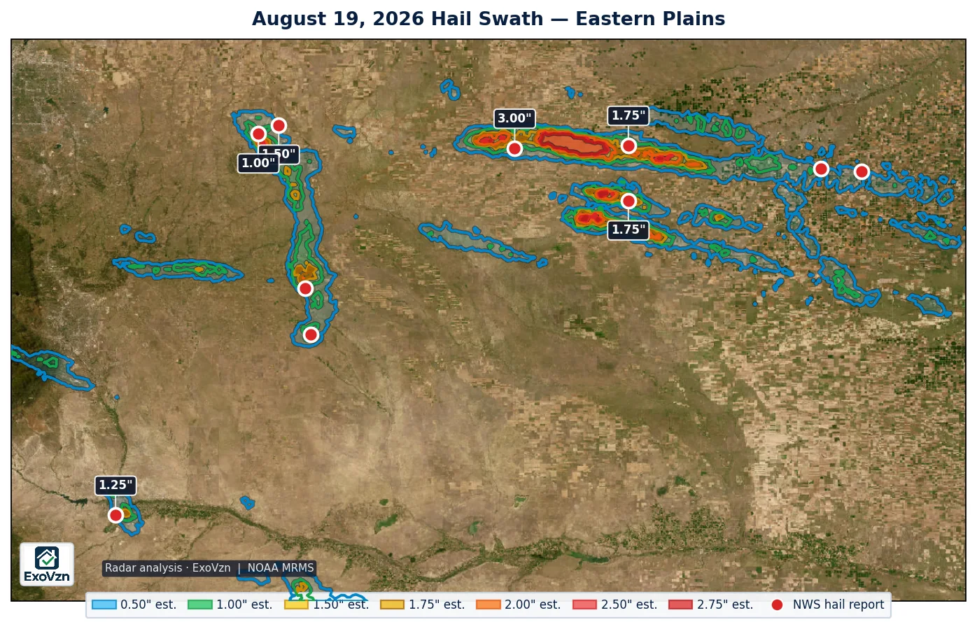
Every Colorado hail report, August 19, 2026
These are National Weather Service Local Storm Reports — hail an observer found on the ground, not a radar estimate. Times are MDT. Measured means a ruler or gauge was put on the stone;reported means a size category or description was relayed to the NWS, which is not a measurement.
| Location | Size | Time | Source | Basis |
|---|---|---|---|---|
| 8 SSW Thurman | 3.00" | 7:26 PM | Trained Spotter | reported |
| 1 NNW Seibert | 1.75" | 7:30 PM | Trained Spotter | reported |
| 13 N Seibert | 1.75" | 8:15 PM | Broadcast Media | measured |
| 4 SSW Deer Trail | 1.50" | 6:29 PM | Trained Spotter | measured |
| 3 WSW Blende | 1.25" | 5:50 PM | Public | measured |
| 8 SW Deer Trail | 1.00" | 6:21 PM | Trained Spotter | measured |
| 6 WSW Agate | 1.00" | 6:52 PM | Storm Chaser | measured |
| 9 NW Kutch | 1.00" | 8:17 PM | Trained Spotter | reported |
| 6 SW Kutch | 1.00" | 8:42 PM | Public | reported |
| 7 NNW Peconic | 0.50" | 9:06 PM | Public | reported |
| 7 NE Peconic | 0.50" | 9:20 PM | Public | reported |
What the 3-inch report does and does not say
The 3.00 inch figure is the largest hail report Colorado has logged since June, and it deserves to be read carefully rather than repeated bare. The spotter’s own remark to the NWS describes hail mostly within the 1 inch range, with a few 3-inch stones hitting the property. That is a normal and honest way for a hailfall to be described — stone sizes within a single storm vary enormously, and the report names the biggest one found. It is a reported size, not a measured one. The largest measured stone of the day was the 1.75 inch report 13 miles north of Seibert.
Both figures matter for roofs, and they say different things. A few 3-inch stones can crack tile, split wood shake and dent metal outright. An inch of hail falling for several minutes is what bruises an asphalt roof across its whole slope.
What radar estimated
The convective-day radar analysis puts roughly 580 square miles of Colorado under estimated hail of 1.00 inch or larger that evening, about 95 square miles at an estimated 2.00 inches or larger, and about 37 square miles at an estimated 2.75 inches or larger — a long, narrow core running west to east across Lincoln and Kit Carson counties. Seibert itself sits inside the estimated 1.75 inch contour, and the reported 1.75 inch stone a mile north-northwest of town falls inside that same contour. The measured1.75 inch stone is a separate observation 13 miles north of Seibert, where the estimate was lower — about 1.00 inch. Radar ran under the ruler there, which is a normal and useful reminder that the two disagree in both directions. Radar hail algorithms output a deliberate high-end estimate of what may exist inside a storm cloud, not a measurement of what landed; treat the shaded swath as the search area and the ground reports as the confirmed observations.
Was any of this near Red Hawk’s service area?
Not really — and that is worth stating plainly. Every report on August 19 came from the eastern plains or the Pueblo area, and the Denver metro saw nothing. The closest report to our service area was a separate early-evening cell that dropped a measured 1.25 inch stone 3 miles west-southwest of Blende at 5:50 PM, about 2.6 miles from Pueblo. If you are in southern Pueblo and heard hail that evening, that is the report to know about — see our hail damage service for what an inspection covers.
Why an inch and a half still matters to an asphalt roof
Impact energy scales hard with stone size. A one-inch stone falls at about 41 mph and lands with roughly 1.3 joules; a 1.75 inch stone falls at about 65 mph and lands with roughly 16 joules — about thirteen times the impact. Published impact studies put the onset of functional damage near 1.00 inch for three-tab asphalt shingles, 1.25 inches for architectural shingles, and 2.00 inches for Class 4 impact-rated products. Nine of the eleven reports on this day were an inch or larger, so most of the affected corridor was at or past the three-tab threshold, and the Seibert and Thurman area was well past all of them.
The damage usually is not visible from the ground. Hail bruises the shingle — fracturing the mat beneath a surface that still looks intact — and the bruised area then sheds its protective granules over the following months.
Radar estimate and ground reports by city — August 19, 2026
The map above is the search area. This table asks two narrower questions for each Red Hawk service-area city: did any NWS ground report come from inside the city’s actual boundary, whatever locality name the NWS filed it under; and did a radar-estimated hail band of 1.00 inch or larger cross that boundary? A ground report is an observation and always lists the city. The band is an MRMS estimate, not a measurement.
| City | Radar estimate | Share of the city under it | Ground reports inside it | Boundary used |
|---|---|---|---|---|
| Pueblo | 1.75" est. | <1% (south part) | 1 report, 1.25″ (measured) | city limits |
Radar estimated hail to 1.75 inches over part of Pueblo (less than 1 percent of it, in its south part); the 1.00 inch band covered about 5 percent of it. On the ground, one National Weather Service hail report came from inside the Pueblo city limits: 1.25 inches (measured). That report was logged by the NWS under the locality name “3 WSW Blende”.
City boundaries are the U.S. Census Bureau TIGER/Line 2025 place limits; Denver neighborhoods use the City and County of Denver’s statistical neighborhood polygons. A city is listed if any NWS ground report came from inside that boundary, or if a 1.00 inch or larger radar band crosses it; a ground report is never left off for the size of the radar estimate. The 0.50 inch band also crossed 3 other service-area cities with no ground report inside them; those are not listed because hail under one inch rarely damages asphalt shingles and a radar band that small is an estimate below that threshold. Bands over cities more than 10 miles from this storm’s own reports belong to other storms on the same day and are not listed here.
Hail duration, warnings and wind
The same system produced 1 Colorado wind report that day, the strongest 58 mph at 5 S Burlington. Wind damage and hail damage look different on a roof and are assessed separately.
CoCoRaHS volunteer observers logged 4 Colorado hail observations on this date, the longest running 35 minutes at Gardner 7.9 SSW. That network records how long hail fell and what it damaged, which NWS storm reports do not capture.
Frequently asked questions
How big was the hail in Colorado on August 19, 2026?
The largest report was 3.00 inches, from a trained spotter 8 miles south-southwest of Thurman at 7:26 PM MDT. That figure needs its context: the spotter reported hail mostly around 1 inch with a few 3-inch stones hitting the property. The largest measured stone that day was 1.75 inches, 13 miles north of Seibert at 8:15 PM.
Was August 19 a significant hail day for Colorado?
Yes. No Colorado hail report had reached two inches since June 24, so this was the first two-inch-plus report of the late season. Eleven hail reports came in statewide, nine of them an inch or larger.
Where did the August 19, 2026 hail fall?
Along a corridor across the eastern plains — from Deer Trail and Agate in Elbert County east through Thurman and Kutch in Lincoln County to Seibert and Peconic in Kit Carson County. A separate cell dropped measured 1.25 inch hail just southwest of Pueblo in the early evening.
Did this storm hit the Denver metro?
No. Every report on August 19 came from the eastern plains or the Pueblo area. The nearest report to Red Hawk's service area was the measured 1.25 inch stone 3 miles west-southwest of Blende, about 2.6 miles from Pueblo.
Could my roof still have damage from this storm?
Yes. Hail bruising fractures the shingle mat beneath a surface that still looks intact, and the bruised area sheds granules over the following months. A roof hit in August can look fine into the fall and start leaking by winter, which is why a ground-level check is worth doing now.
Were there damaging winds in Colorado on August 19, 2026?
Yes. The National Weather Service logged 1 wind report in Colorado on August 19, 2026, the strongest 58 mph at 5 S Burlington. Wind and hail damage a roof differently — wind lifts and creases shingles along edges and ridges, hail bruises the field.
How long did hail fall in Colorado on August 19, 2026?
CoCoRaHS volunteer observers — a trained precipitation network separate from NWS storm spotters — logged 4 hail observations in Colorado on August 19, 2026. The longest was 35 minutes at Gardner 7.9 SSW. CoCoRaHS reports carry duration and damage notes that an NWS report does not.
Was there hail in Pueblo on August 19, 2026?
Radar estimated hail to 1.75 inches over part of Pueblo (less than 1 percent of it, in its south part); the 1.00 inch band covered about 5 percent of it. On the ground, one National Weather Service hail report came from inside the Pueblo city limits: 1.25 inches (measured). That report was logged by the NWS under the locality name “3 WSW Blende”.
Red Hawk tracks every significant hail day across Colorado. See the 2026 season archive for every covered event, or start with what hail damage actually looks like on a roof and the Colorado hail claim guide.
Red Hawk works Colorado roofs year round. We'll still be here next season.
Schedule My Free Inspectionor call (720) 771-8921
Storm figures are National Weather Service Local Storm Reports for Colorado on August 19, 2026 (local time), retrieved from the Iowa Environmental Mesonet archive, de-duplicated, and cross-checked against StormIntelDB. Times are MDT and reports are grouped by the local calendar day. Radar swath analysis by ExoVzn, an independent forensic meteorology firm, using NOAA MRMS data; radar areas are estimates, clipped to Colorado. Impact-energy and damage-threshold figures are from published hail impact research. Storm reports indicate where hail occurred; only a physical inspection establishes whether a specific roof was damaged.