

Colorado Hail Storm Report, August 12, 2026: Haxtun
September 11, 2026
By Red Hawk Roofing
Updated September 23, 2026 with complete verified storm reports.
A hail-producing storm crossed Colorado on August 12, 2026. The National Weather Service has logged 1 hail report in this storm’s footprint for that date, the largest at 1.00 inches. Haxtun took the most reports.
The Colorado hail map — August 12, 2026
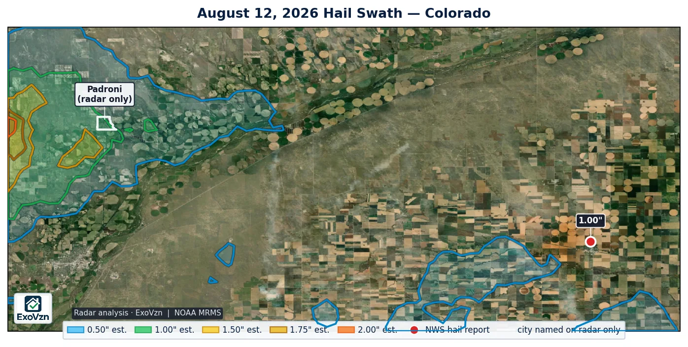
Every hail report in Colorado
These are National Weather Service Local Storm Reports — hail an observer found on the ground, not a radar estimate. Times are MDT. “Measured” means the stone was physically measured; “reported” means a size category or description was relayed to the NWS — mPING and public descriptions are not measurements.
| Location | Size | Time | Source | Basis |
|---|---|---|---|---|
| Haxtun | 1.00" | 6:53 PM | Public | reported |
By city: Haxtun 1 report. A hail report always names the largest stone an observer found, not the average size that fell across every roof.
Was your address in this one? We'll come look, free.
Schedule My Free Inspectionor call (720) 771-8921
Why 1.00-inch hail matters to an asphalt roof
Damage scales hard with stone size. A one-inch stone falls at about 41 mph and lands with roughly 1.3 joules of energy. A 1.75 inch stone falls at about 65 mph and lands with roughly 16 joules — about thirteen times the impact. Denver-area elevation adds another 8 to 10 percent to fall speed.
Published impact studies put the onset of functional damage near 1.00 inch for three-tab asphalt shingles, 1.25 inches for architectural shingles, and 2.00 inches for Class 4 impact-rated products. The largest report in Colorado this day was 1.00 inches, at or near the threshold for three-tab shingles.
The damage usually is not visible from the ground. Hail bruises the shingle — fracturing the mat beneath a surface that still looks intact — and the bruised area then sheds its protective granules over the following months. A roof hit in June can look fine all summer and start leaking by winter.
Radar-estimated hail is not measured hail
Radar hail algorithms output a deliberate high-end estimate of what may exist inside a storm cloud, not a measurement of what landed on your roof. Radar estimates characteristically run above what observers actually recover. Treat the shaded swath on the map as the search area and the ground reports as the confirmed observations. If a contractor tells you radar showed three-inch hail at your address, ask whether anyone measured it.
For this storm, MRMS radar estimated hail reaching the 0.50 inch contour band, about 2.5 miles from the nearest ground report. The largest stone anyone actually measured on the ground was 1.00 inch. Radar estimates and ground reports measure different things, so they routinely disagree; both are shown here rather than the more flattering one.
Radar estimate and ground reports by city — August 12, 2026
The map above is the search area. This table asks two narrower questions for each Colorado city in the storm footprint: did any NWS ground report come from inside the city’s actual boundary, whatever locality name the NWS filed it under; and did a radar-estimated hail band of 1.00 inch or larger cross that boundary? A ground report is an observation and always lists the city. The band is an MRMS estimate, not a measurement.
| City | Radar estimate | Share of the city under it | Ground reports inside it | Boundary used |
|---|---|---|---|---|
| Padroni | 1.00" est. | 77% (southwest part) | none | city limits |
Radar estimated hail to 1.00 inch over part of Padroni (about 77 percent of it, in its southwest part). No ground observer reported from Padroni that day — reports come from where people happen to be, and their absence is not evidence that nothing fell. The nearest ground report of any size that day was about 29 miles away at “Haxtun” (1.00 inch, reported).
The strongest radar-estimated core of this storm, the 0.50 inch band, crossed no Colorado city. It sits over unincorporated Yuma County, Washington County, Logan County and Phillips County, ZIP codes 80728, 80731 and 80759, about 1.6 miles southwest of the Haxtun city limit. Named roads under it: County Road 83, County Road 18, County Road 16 and County Road 1. The nearest ground report was 2.5 miles away (“Haxtun”, 1.00 inch). No ground observer reported from inside it — reports come from where people happen to be, and their absence is not evidence that nothing fell.
City boundaries are the U.S. Census Bureau TIGER/Line 2025 place limits; Denver neighborhoods use the City and County of Denver’s statistical neighborhood polygons. A city is listed if any NWS ground report came from inside that boundary, or if a 1.00 inch or larger radar band crosses it; a ground report is never left off for the size of the radar estimate. The 0.50 inch band also crossed 4 other Colorado cities with no ground report inside them; those are not listed because hail under one inch rarely damages asphalt shingles and a radar band that small is an estimate below that threshold.
Hail duration, warnings and wind
The National Weather Service logged 1 wind report within 10 miles of this storm’s hail reports that day, the strongest 61 mph at Haxtun. Wind damage and hail damage look different on a roof and are assessed separately.
CoCoRaHS volunteer observers logged 1 Colorado hail observation on this date, the longest running 2 minutes at Crestone 1.2 SSE. That network records how long hail fell and what it damaged, which NWS storm reports do not capture.
What to do if you were under it
- Check from the ground, not the roof. Walking a hail-struck roof is how people get hurt.
- Look in your gutters. Granules washing off in quantity is the most common early sign.
- Check soft metal. Roof vents, gutters, flashing, the mailbox, AC condenser fins. Dents in soft metal date the storm.
- Photograph what you find with your phone. Phone photos carry a timestamp. Do not edit them.
- Get it inspected. Especially if this storm was months ago — that is exactly when bruising starts to surface.
Frequently asked questions
Was there hail in Haxtun on August 12, 2026?
Yes. The National Weather Service logged 1 hail report in the Haxtun area on August 12, 2026. Across Colorado there were 1 reports that day, topping out at 1.00 inches.
How big was the hail on August 12, 2026 in Colorado?
The largest hail reported in Colorado is 1.00 inches. Remember that a hail report names the largest stone found, not what fell across a whole neighborhood.
Which Colorado towns had hail on August 12, 2026?
Reports came in from Haxtun.
Could my roof still have damage from this storm?
Yes. Hail bruising fractures the shingle mat beneath a surface that still looks intact, and the bruised area sheds granules over the following months. Damage from a storm earlier in the season is often only becoming visible now, which is exactly why it is worth checking.
How do I check my roof for hail damage?
From the ground, never by climbing up. Look for granules collecting in gutters and at downspout outlets, and dents in soft metal such as roof vents, gutters, flashing, the mailbox and AC condenser fins. Soft-metal dents matter most because they date the storm.
Was there hail in Padroni on August 12, 2026?
Radar estimated hail to 1.00 inch over part of Padroni (about 77 percent of it, in its southwest part). No ground observer reported from Padroni that day — reports come from where people happen to be, and their absence is not evidence that nothing fell. The nearest ground report of any size that day was about 29 miles away at “Haxtun” (1.00 inch, reported).
Were there damaging winds in Colorado on August 12, 2026?
Yes. The National Weather Service logged 1 wind report within 10 miles of this storm's hail reports on August 12, 2026, the strongest 61 mph at Haxtun. Wind and hail damage a roof differently — wind lifts and creases shingles along edges and ridges, hail bruises the field.
How long did hail fall in Colorado on August 12, 2026?
CoCoRaHS volunteer observers — a trained precipitation network separate from NWS storm spotters — logged 1 hail observation in Colorado on August 12, 2026. The longest was 2 minutes at Crestone 1.2 SSE. CoCoRaHS reports carry duration and damage notes that an NWS report does not.
Red Hawk tracks every hail day across the Front Range. See our other storm reports for the rest of the 2026 season.
Not sure what to look for? Start with what hail damage looks like on a roof and the Colorado hail claim guide.
Red Hawk works Colorado roofs year round. We'll still be here next season.
Schedule My Free Inspectionor call (720) 771-8921
Storm figures are National Weather Service Local Storm Reports for Colorado on August 12, 2026 (local time), retrieved from the Iowa Environmental Mesonet archive and de-duplicated. Radar swath analysis by ExoVzn, an independent forensic meteorology firm, using NOAA MRMS data. Impact-energy and damage-threshold figures are from published hail impact research. Storm reports indicate where hail occurred; only a physical inspection establishes whether a specific roof was damaged.