

Colorado Hail Storm Report, June 22, 2026: Measured 3-Inch Hail in Sterling, 4-Inch Stones Near Joes
August 16, 2026
By Red Hawk Roofing
June 22, 2026 was Colorado’s biggest hail day of the year. Trained spotters measured 3.00 inch hail on the west edge of Sterling and 2.50 inch hail on its south side, a spotter west of Joes measured multiple 4.00 inch stones that evening, and a separate complex dropped 2.00 to 2.25 inch hail across the Arkansas Valley between Boone, Olney Springs and Fowler — 22 reports of 1.75 inch or larger hail statewide, the most of any day this season.
The Sterling and northeast plains hail map — June 22, 2026
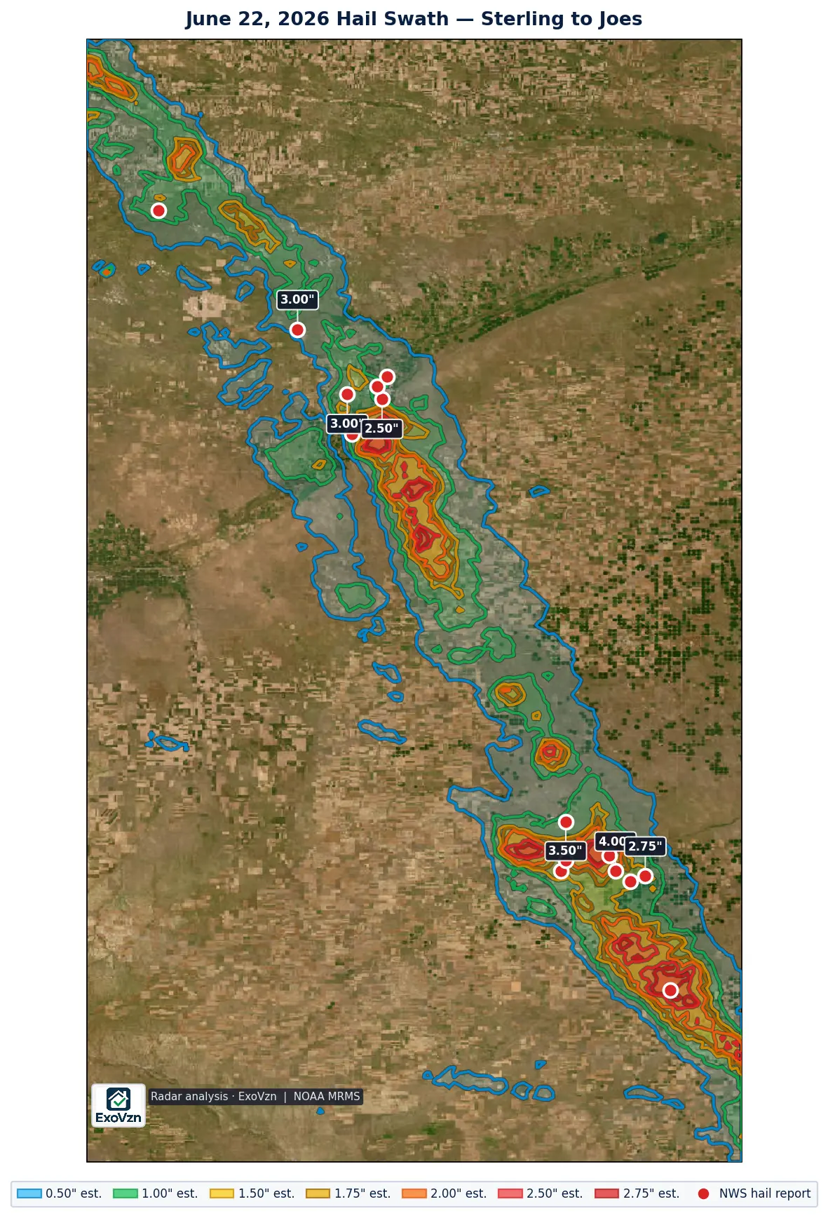
Sterling took measured 3-inch hail in town
This is the strongest verified in-town large-hail event of the 2026 season anywhere in Colorado. The hail reached the Sterling area at 4:49 PM and worked across the city for about twenty minutes — 1.75 inches measured a mile northeast, 3.00 inches measured four miles west at 4:55 PM, then 2.50 inches measured on the south side at 4:58 and 5:07 PM. Every one of those is a measurement, not an estimate. Sterling had been under eight successive severe thunderstorm warnings starting at 3:12 PM — more than 90 minutes of continuous warned lead — plus a tornado warning at 5:29 PM, and a mesonet station east of town recorded a 59 mph gust as the storm arrived.
The same line kept going. At 6:12 PM the Akron ASOS — an NWS-grade instrument — measured a 109 mph gust, with nearby mesonet stations recording 92 to 113 mph and power lines down along US-34 between Akron and Otis. By 7:19 PM a spotter north of Cope measured 3.50 inch hail, and at 7:54 PM the spotter west of Joes measured 4.00 inch stones — “Multiple 4 inch hail stones reported,” in the words of the report.
Every large-hail report — Sterling to the eastern plains
These are National Weather Service Local Storm Reports. Measured means an observer put a ruler or gauge on the stone; reported means a size category or estimate was relayed. Times are MDT.
| Location | Size | Time | Source | Basis |
|---|---|---|---|---|
| 3 W Joes | 4.00" | 7:54 PM | Trained Spotter | measured |
| 6 N Cope | 3.50" | 7:19 PM | Trained Spotter | measured |
| 6 WSW North Sterling Reservoir | 3.00" | 4:23 PM | Storm Chaser | measured |
| 4 W Sterling | 3.00" | 4:55 PM | Trained Spotter | measured |
| Joes | 2.75" | 8:01 PM | Public | reported |
| 2 SSE Sterling | 2.50" | 4:58 PM | Public | measured |
| 1 S Sterling | 2.50" | 5:07 PM | Storm Chaser | measured |
| 3 W Joes | 2.50" | 8:19 PM | Public | reported |
| 17 S Kimball, Neb. (far NE Weld County) | 2.00" | 4:08 PM | Trained Spotter | measured |
| 1 S Cope | 2.00" | 7:27 PM | Storm Chaser | reported |
| 1 SSE Cope | 2.00" | 7:37 PM | Storm Chaser | measured |
| 4 NNW Joes | 2.00" | 7:59 PM | Public | reported |
| 8 N Stratton | 2.00" | 8:32 PM | Trained Spotter | reported |
| 1 NE Sterling | 1.75" | 4:49 PM | Trained Spotter | measured |
| 1 S Atwood | 1.75" | 5:08 PM | Storm Chaser | reported |
| 2 WSW Joes | 1.75" | 7:51 PM | Fire Dept/Rescue | reported |
The 2.00 inch row is 17 miles south of Kimball, Nebraska — inside far northeastern Weld County, Colorado.
Buildings or equipment under this one? We'll come look, free.
Schedule My Free Inspectionor call (720) 771-8921
The Arkansas Valley round — same day, different storm
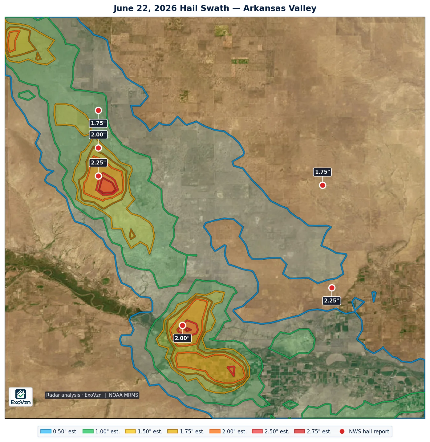
While the northeast plains storms were organizing, a separate complex under WFO Pueblo worked the Arkansas Valley. A chaser measured 2.25 inch hail north-northeast of Olney Springs at 5:12 PM — he drove through the hail core and made the measurement — with 2.00 to 2.25 inch hail reported around Boone, the Pueblo Depot area and northwest of Fowler. Radar put Fowler itself inside the estimated 1.50 inch contour, a third of a mile from the estimated 2.00 inch core. This round was also tornado-warned: law enforcement reported a funnel cloud at Fowler at 5:10 PM and a tornado a mile west at 5:22 PM, and a chaser reported a tornado southwest of town from 5:42 to 5:47 PM.
| Location | Size | Time | Source | Basis |
|---|---|---|---|---|
| 7 NE Boone | 2.25" | 5:10 PM | Public | reported |
| 3 NNE Olney Springs | 2.25" | 5:12 PM | Storm Chaser | measured |
| 8 E Pueblo Depot | 2.00" | 5:05 PM | Public | reported |
| 5 NW Fowler | 2.00" | 5:32 PM | Public | reported |
| 10 NNW Crowley | 1.75" | 5:01 PM | Storm Chaser | measured |
| 9 NE Pueblo Depot | 1.75" | 5:01 PM | Public | reported |
How big was this day, statewide
Radar analysis puts roughly 1,275 square miles of Colorado under estimated 1.00 inch or larger hail on June 22, about 243 square miles under estimated 2.00 inch or larger — the season’s largest footprint — and about 30 square miles under estimated 2.75 inch or larger. Those are estimates; the measured stones in the tables above are the ground truth, and at Sterling the measured 3.00 inch stones out-ran what radar estimated over the town itself. Radar and ground agreed closely on the Joes–Cope corridor, where the estimated 2.75 inch cores straddle the spots where the 4.00 and 3.50 inch stones were measured.
Red Hawk’s Front Range service area saw a much smaller storm the same day — three reports topping out at 1.50 inches in Fountain. That event has its own report.
Why measured 3-and-4-inch hail matters
Damage scales hard with stone size. A one-inch stone falls at about 41 mph and lands with roughly 1.3 joules of energy. A 1.75 inch stone falls at about 65 mph and lands with roughly 16 joules — about thirteen times the impact. Published impact studies put the onset of functional damage near 1.00 inch for three-tab shingles, 1.25 inches for architectural shingles, and 2.00 inches for Class 4 impact-rated products. Stones of 3.00 and 4.00 inches are past the threshold for every asphalt roofing product made, and they break skylights, crack fiber-cement siding, and total pivot-irrigation panels and vehicle glass.
What to do if you were under it
- Check from the ground, not the roof. Walking a hail-struck roof is how people get hurt.
- Look in your gutters. Granules washing off in quantity is the most common early sign.
- Check soft metal. Roof vents, gutters, flashing, the mailbox, AC condenser fins. Dents in soft metal date the storm.
- Photograph what you find with your phone. Phone photos carry a timestamp. Do not edit them.
- Get it inspected. Especially if this storm was months ago — that is exactly when bruising starts to surface.
Radar estimate and ground reports by city — June 22, 2026
The map above is the search area. This table asks two narrower questions for each Red Hawk service-area city: did any NWS ground report come from inside the city’s actual boundary, whatever locality name the NWS filed it under; and did a radar-estimated hail band of 1.00 inch or larger cross that boundary? A ground report is an observation and always lists the city. The band is an MRMS estimate, not a measurement.
No National Weather Service ground report in this report’s footprint fell inside a Red Hawk service-area city boundary, and no 1.00 inch or larger radar band crossed one within 10 miles of its reports.
The strongest radar-estimated core of this storm, the 2.75 inch band (the largest of 14 separate cores at that band), crossed no Red Hawk service-area city. It sits over unincorporated Kit Carson County, ZIP code 80836, about 74.5 miles southeast of the Brush city limit. Named roads under it: County Road 29, County Road Ee, County Road 28 and County Road Ff. A ground report came from inside it: “8 N Stratton”, 2.00 inches, reported.
City boundaries are the U.S. Census Bureau TIGER/Line 2025 place limits; Denver neighborhoods use the City and County of Denver’s statistical neighborhood polygons. A city is listed if any NWS ground report came from inside that boundary, or if a 1.00 inch or larger radar band crosses it; a ground report is never left off for the size of the radar estimate. This date has more than one storm report; this section covers the cities within this report’s own footprint, and the rest of the date’s cities are listed in the companion report for June 22, 2026.
Hail duration, warnings and wind
The same system produced 26 Colorado wind reports that day, the strongest 113 mph at 1 W Akron. Wind damage and hail damage look different on a roof and are assessed separately.
CoCoRaHS volunteer observers logged 3 Colorado hail observations on this date, the longest running 12 minutes at Security 0.5 NE. That network records how long hail fell and what it damaged, which NWS storm reports do not capture.
Frequently asked questions
Was there hail in Sterling, Colorado on June 22, 2026?
Yes. Trained spotters and chasers measured 3.00 inch hail four miles west of Sterling at 4:55 PM MDT, 2.50 inch hail on the town's south side minutes later, and 1.75 inch hail a mile northeast at 4:49 PM. Sterling had been under continuous severe thunderstorm warnings for over 90 minutes before the first in-town hail.
How big was the hail in Colorado on June 22, 2026?
The largest measured stone was 4.00 inches, three miles west of Joes at 7:54 PM — the spotter reported multiple 4 inch hail stones. A 3.50 inch stone was measured north of Cope, 3.00 inches at Sterling and near North Sterling Reservoir, and 2.00 to 2.25 inch hail fell in the Arkansas Valley between Boone, Olney Springs and Fowler.
Was June 22 the biggest hail day of 2026 in Colorado?
Yes. June 22 produced 22 reports of 1.75 inch or larger hail — the most of any 2026 day — and the season's largest radar hail footprint: an estimated 243 square miles of 2.00 inch or larger hail across the state. Radar figures are estimates; the measured stones above are the ground truth.
Were there tornadoes with this storm?
In the Arkansas Valley, law enforcement reported a funnel cloud at Fowler at 5:10 PM and a tornado one mile west of Fowler at 5:22 PM, and a storm chaser reported a tornado southwest of Fowler from 5:42 to 5:47 PM. Sterling was also under a tornado warning from 5:29 to 5:40 PM.
Can 3-inch hail damage a roof?
Yes, severely. Published impact studies put the onset of functional damage near 1.00 inch for three-tab shingles, 1.25 inches for architectural shingles, and 2.00 inches for Class 4 impact-rated products. A measured 3.00 inch stone is past the threshold for every asphalt product on the market, and it will also crack skylights, dent metal roofing and break fiber-cement siding.
Could my roof still have damage from this storm?
Yes. Hail bruising fractures the shingle mat beneath a surface that still looks intact, and the bruised area sheds granules over the following months. Damage from a storm earlier in the season is often only becoming visible now, which is exactly why it is worth checking.
Were there damaging winds in Colorado on June 22, 2026?
Yes. The National Weather Service logged 26 wind reports in Colorado on June 22, 2026, the strongest 113 mph at 1 W Akron. Wind and hail damage a roof differently — wind lifts and creases shingles along edges and ridges, hail bruises the field.
How long did hail fall in Colorado on June 22, 2026?
CoCoRaHS volunteer observers — a trained precipitation network separate from NWS storm spotters — logged 3 hail observations in Colorado on June 22, 2026. The longest was 12 minutes at Security 0.5 NE. CoCoRaHS reports carry duration and damage notes that an NWS report does not.
Red Hawk tracks every significant hail day across Colorado. See the 2026 season archive for every covered event, and our storm reports hub for how these reports are built. Before any adjuster visit, read what hail damage actually looks like on a roof and the Colorado hail claim guide, or see our hail damage service for what an inspection covers.
Red Hawk works Colorado roofs year round. We'll still be here next season.
Schedule My Free Inspectionor call (720) 771-8921
Storm figures are National Weather Service Local Storm Reports for Colorado on June 22, 2026, retrieved from the Iowa Environmental Mesonet archive and de-duplicated; warning times are from the NWS watch/warning archive. Times are MDT and reports are grouped by the local calendar day. Radar swath analysis by ExoVzn, an independent forensic meteorology firm, using NOAA MRMS data. Radar figures are estimates. Storm reports indicate where hail occurred; only a physical inspection establishes whether a specific roof or structure was damaged.