

Colorado Hail Storm Report, May 21, 2026: 4.5-Inch Stones Reported on the Eastern Plains — the Largest Hail of the Season
August 16, 2026
By Red Hawk Roofing
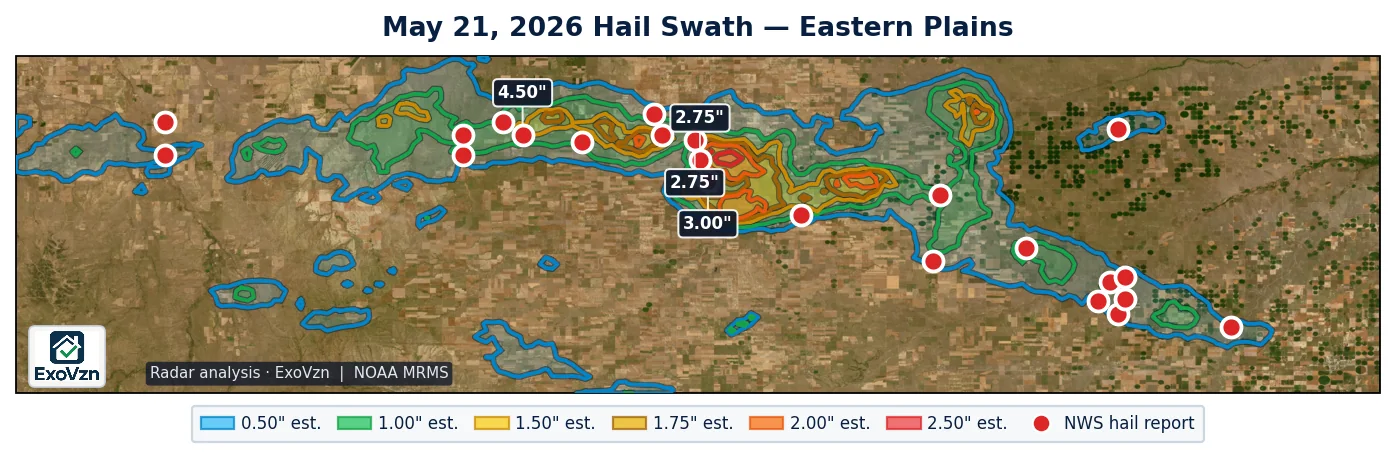
The largest hail reported anywhere in Colorado in 2026 fell on May 21: a storm chaser estimated 4.50 inch stones seven miles southeast of Last Chance, and a trained spotter measured 2.75 inches near Thurman minutes earlier. A supercell train ran seven hours from Deer Trail southeast across Washington and Kit Carson counties, producing 23 hail reports and three brief reported tornadoes along the way.
The eastern plains hail map — May 21, 2026
Every hail report along the track
These are National Weather Service Local Storm Reports. Measured means an observer put a ruler or gauge on the stone; reported means a size category or estimate was relayed — including the 4.50 inch headline stone, which is a chaser estimate, not a measurement. The largest measured stone was 2.75 inches. Times are MDT.
| Location | Size | Time | Source | Basis |
|---|---|---|---|---|
| 7 SE Last Chance | 4.50" | 5:50 PM | Storm Chaser | reported |
| 1 S Thurman | 3.00" | 5:47 PM | Trained Spotter | reported |
| 1 S Thurman | 2.75" | 5:44 PM | Public | reported |
| 2 WNW Thurman | 2.75" | 5:44 PM | Trained Spotter | measured |
| 5 SSE Last Chance | 2.50" | 5:06 PM | Trained Spotter | measured |
| 6 S Lindon | 2.50" | 5:19 PM | Storm Chaser | reported |
| 12 S Joes | 2.50" | 7:48 PM | Public | reported |
| 7 NNW Stratton | 2.50" | 7:55 PM | Storm Chaser | measured |
| 5 N Stratton | 2.00" | 8:10 PM | Public | reported |
| 7 S Last Chance | 1.75" | 4:58 PM | Storm Chaser | reported |
| 5 N Stratton | 1.75" | 8:10 PM | Public | reported |
| 5 N Stratton | 1.75" | 8:17 PM | Public | reported |
| 4 N Bethune | 1.75" | 8:48 PM | Public | reported |
| 3 N Deer Trail | 1.50" | 4:02 PM | Public | reported |
| 11 N Seibert | 1.50" | 5:31 PM | Storm Chaser | reported |
| 9 SE Thurman | 1.50" | 6:07 PM | Public | reported |
| 5 NW Thurman | 1.25" | 5:34 PM | Public | reported |
| 8 N Stratton | 1.25" | 8:23 PM | Public | reported |
| Deer Trail | 1.00" | 3:44 PM | Storm Chaser | measured |
| 5 S Last Chance | 1.00" | 4:50 PM | Storm Chaser | reported |
| 5 NW Thurman | 1.00" | 5:31 PM | Public | reported |
| 12 WSW Joes | 1.00" | 7:11 PM | Storm Chaser | reported |
| 2.6 N Kirk | 1.00" | 11:28 PM | Public | reported |
The track reads west to east: a measured 1.00 inch stone at Deer Trail at 3:44 PM — fourteen minutes after the first severe thunderstorm warning — then the Last Chance and Thurman reports through the late afternoon, the Seibert and Joes-area reports in the evening, and the Stratton and Bethune reports after 7:55 PM, with a final 1.00 inch report near Kirk at 11:28 PM. The same supercell also produced three brief tornadoes reported near Thurman between 5:35 and 5:47 PM, inside four consecutive tornado warnings.
Buildings or equipment along this track? We'll come look, free.
Schedule My Free Inspectionor call (720) 771-8921
What radar saw
All radar figures are estimates. The convective-day analysis puts about 363 square miles of Colorado under estimated 1.00 inch or larger hail, 54 square miles under 1.75 inch or larger, and a roughly 2 square mile core of estimated 2.50 inch or larger directly over the Thurman–Lindon corridor — the same ground the 2.75 inch measured and 4.50 inch reported stones came from. Radar and ground agree on where the worst of it fell. The towns themselves sat between the cores: the giant hail fell on ranchland and county roads, which is exactly why most of the reports came from chasers and spotters following the storm rather than residents.
Why this day is the season benchmark
Rooftop exposure on this track was low — the corridor between Deer Trail and Stratton is rural. But 2-to-4-inch-class hail is a different animal from the 1-inch storms that make up most of a season: published impact studies put functional damage onset near 1.00 inch for three-tab shingles, 1.25 inches for architectural shingles, and 2.00 inches for Class 4 impact-rated products, and stones in this class also destroy skylights, dent metal roofing and grain bins, and break pivot-irrigation panels. If you own structures or equipment along US-36 or I-70 east of Deer Trail, May 21 is the storm to check against.
Frequently asked questions
How big was the hail in Colorado on May 21, 2026?
The largest reported stone of the entire 2026 Colorado season fell that evening: 4.50 inches, a storm-chaser size estimate seven miles southeast of Last Chance at 5:50 PM. The largest measured stone was 2.75 inches, two miles west-northwest of Thurman, with measured 2.50 inch stones near Last Chance and north of Stratton.
Where did the May 21, 2026 hail storm hit?
A long-lived supercell train ran about seven hours from Deer Trail on I-70 southeast across Washington County — Last Chance, Lindon, Thurman — into Kit Carson County near Seibert, Stratton and Bethune. The giant hail fell mostly on ranchland and county roads between the towns.
Were there tornadoes on May 21, 2026 in Colorado?
Three brief tornadoes were reported near Thurman between 5:35 and 5:47 PM, one lasting about four minutes. No damage was reported. The same storm also held four consecutive tornado warnings over the Thurman and Last Chance area between 4:52 and 6:32 PM.
Why are most of these reports estimates rather than measurements?
Because almost nobody lives where the stones fell. The reports that exist came largely from storm chasers and spotters following the storm, filing size categories through mPING and social media. A reported size is a category someone selected; a measured size means a ruler or gauge was put on the stone. This report keeps the two separate everywhere.
Could buildings or equipment still have damage from this storm?
Yes. Hail bruising on asphalt shingles works to the surface over months, and 2-to-4-inch-class stones also dent metal roofing and grain bins, crack skylights and break pivot-irrigation panels. If you have structures or equipment along the US-36 or I-70 corridors between Deer Trail and Stratton, a documented inspection is worth it.
Red Hawk tracks every significant hail day across Colorado. See the 2026 season archive for every covered event, and our storm reports hub for how these reports are built. Before any adjuster visit, read what hail damage actually looks like on a roof and the Colorado hail claim guide, or see our hail damage service for what an inspection covers.
Red Hawk works Colorado roofs year round. We'll still be here next season.
Schedule My Free Inspectionor call (720) 771-8921
Storm figures are National Weather Service Local Storm Reports for Colorado on May 21, 2026, retrieved from the Iowa Environmental Mesonet archive and de-duplicated; warning times are from the NWS watch/warning archive. Times are MDT and reports are grouped by the local calendar day. Radar swath analysis by ExoVzn, an independent forensic meteorology firm, using NOAA MRMS data. Radar figures are estimates. Storm reports indicate where hail occurred; only a physical inspection establishes whether a specific roof or structure was damaged.