

Colorado Hail Storm Report, August 15, 2026: Ken Caryl, Morrison, Lone Tree and Parker
August 16, 2026
By Red Hawk Roofing
A slow, water-heavy thunderstorm crossed the south Denver metro on the afternoon of Saturday, August 15, 2026. Radar analysis put hail of an inch or larger over two separate pockets — the Ken Caryl and Morrison foothills, and a second core over Lone Tree, Parker and Foxfield. At one Meridian intersection first responders found two to three feet of hail under the flood water. Centennial Airport measured a 64 mph gust and took more than an inch of rain in under 40 minutes. Three ways to damage a roof, in one storm.
Where the hail was
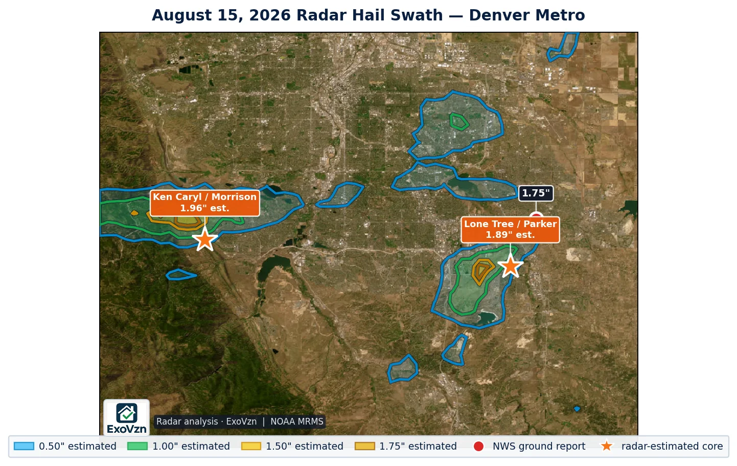
Radar identified roughly 31.5 square miles of 1.00 inch or larger hail inside the metro, concentrated in two discrete pockets rather than spread across the whole area:
| Core | Communities | Size | Area |
|---|---|---|---|
| Ken Caryl and Morrison foothills | west Littleton, Ken Caryl, Morrison | 1.96″ est. | ~10 sq mi |
| Lone Tree, Parker and Foxfield | Lone Tree, Parker, Foxfield, south Centennial | 1.89″ est. | ~10 sq mi |
A ground observer two miles southwest of Foxfield reported golf-ball hail, about 1.75 inches, at 2:19 PM — sitting right on the edge of the southeast core and matching what radar showed there.
Was your address in one of those cores? We'll come look, free.
Schedule My Free Inspectionor call (720) 771-8921
Two to three feet of it, under the flood water
Colorado logged only three official National Weather Service hail reports on August 15, and just one in the metro. That number badly understates what happened, and it is worth understanding why.
The hail was widely reported — just not through the Weather Service. CBS Colorado reported that at the intersection of Meridian Boulevard and Maroon Circle in Meridian, first responders found roughly three feet of water on the road with two to three feet of hail underneath it. The same coverage described the Ken Caryl community in the southwest metro taking a significant amount of hail, with video showing ice covering roads and yards.
South Metro Fire Rescue ran seven water rescues from stranded vehicles between 2:30 and 4:00 PM. Aurora Fire Rescue fielded more than fifteen 911 calls for flooded roadways and homes. Both of the radar cores on the map above show up in that reporting.
So why only one NWS report? Storm reports are a volunteer sample, not a census. A Local Storm Report exists only when someone happens to be outside, measures or estimates the hail, and takes the trouble to file it with the Weather Service. On August 15 the people who were outside were pulling drivers out of flooded intersections, and the people who weren’t were indoors behind a downpour heavy enough to drop visibility to a quarter mile.
A thin official report count is evidence that few people filed reports. It is not evidence that hail did not fall — and on this storm, the news coverage and the radar agree with each other.
The wind and the water
Hail was not the only thing this storm did, and for a lot of roofs it may not even have been the main thing.
The AWOS at Centennial Airport measured a 64 mph gust at 2:16 PM. That is a measured value from an instrument, not an estimate. It sits above the 45 to 60 mph range where three-tab asphalt shingles begin to fail and at the low end of the 60 to 80 mph range for architectural shingles.
The same station went from 0.03 inches of rain at 2:15 PM to 1.17 inches by 2:53 PM — more than an inch in under 40 minutes, with visibility down to a quarter mile. For contrast, Denver International recorded 0.28 inches and a 30 mph gust in the same period. This storm was small, slow and parked over the south metro.
10 flood and flash-flood reports followed between 2:32 to 3:10 PM — Cherry Creek Reservoir, Aurora, Lone Tree, Arapahoe Park — and flash flood warnings stayed up until 5:45 PM.
Every ground report
These are National Weather Service Local Storm Reports. Measured means an observer used an instrument. Reported means a size category was selected — golf ball, quarter — which is how most public reports arrive.
| Location | County | Value | Time | Basis |
|---|---|---|---|---|
| 2 miles SSW of Foxfield | Arapahoe | 1.75" | 2:19 PM | reported |
| 12 miles NE of Two Buttes | Prowers | 1.50" | 6:02 PM | measured |
| 4 miles south of Rush | El Paso | 1.00" | 5:49 PM | reported |
| Centennial Airport | Arapahoe | 64 mph | 2:16 PM | measured |
| Springfield | Baca | 63 mph | 5:56 PM | measured |
| Walsh area | Baca | 64 mph | 6:10 PM | measured |
What the National Weather Service did
NWS Boulder issued three back-to-back severe thunderstorm warnings that swept the metro west to east:
- 1:26 PM — Denver, Littleton, Englewood, Morrison, Highlands Ranch
- 2:10 PM — Parker, Centennial, Lone Tree, Foxfield
- 2:58 PM — Aurora
Each carried a 1.00" hail tag and a 60 mph wind tag. A severe thunderstorm watch was issued at 2:05 PM covering eastern Colorado. The Storm Prediction Center had the metro at Marginal risk with a 5 percent hail probability, with Parker at Slight.
Out on the eastern plains it ran far longer — warnings from 12:58 PM until 7:30 PM, hail tags up to 1.75 inches, and power poles snapped along a two-mile stretch of Highway 287near Springfield. Colorado’s largest radar estimate of the day, about 2.52 inches, was down there in Baca and Prowers counties — not in the metro.
Hail, 64 mph wind and an inch of rain in 40 minutes. Worth a look.
Schedule My Free Inspectionor call (720) 771-8921
Radar-estimated hail is not measured hail
The sizes on the map above are radar estimates. Radar hail algorithms output a high-end estimate of what may exist inside a storm cloud, and they characteristically run above what an observer recovers on the ground. Heavy rain can push them higher still, because the algorithm reads reflectivity and a water-loaded core reflects strongly.
What radar is genuinely good at is showing the shape of a swath between the handful of places where somebody happened to be standing. With one metro report to work from, radar is most of what there is. Treat the shaded area as the search zone — and if a contractor tells you radar showed three-inch hail at your address, ask whether anyone measured it.
How to check your roof
Hail damage is rarely visible from the ground. A stone bruises the shingle by fracturing the mat beneath a surface that still looks intact, and the bruised area sheds its protective granules over the following months. Wind damage at 64 mph starts at edges, rakes and ridges, where uplift is highest, and usually shows as sealant-strip failure or edge peel-back rather than missing shingles.
From the ground — never climb up:
- Granules collecting in gutters and at downspout outlets
- Dents in soft metal — roof vents, gutters, flashing, the mailbox, AC condenser fins
- Shingle edges lifted or curled along rakes and ridges
- Splatter marks on decking, fascia or fence tops
- Any new interior staining after that much rain in 40 minutes
Roof age matters more than the storm did. Research published by the Insurance Institute for Business & Home Safety in 2025 found that shingles previously exposed to weathering and sub-severe hail were roughly ten times more susceptible to damage in a later event. An older roof that took hail on August 13 is not starting from zero.
Frequently asked questions
Was there hail in the Denver metro on August 15, 2026?
Yes. Radar analysis identified two pockets of 1.00 inch or larger hail — one over the Ken Caryl and Morrison foothills peaking at an estimated 1.96 inches, and one over Lone Tree, Parker and Foxfield peaking at an estimated 1.89 inches. A ground observer near Foxfield reported golf-ball hail of about 1.75 inches at 2:19 PM.
Which areas had hail on August 15?
The two radar-identified cores covered west Littleton, Ken Caryl and Morrison in the southwest, and Lone Tree, Parker, Foxfield and south Centennial in the southeast. Together they total roughly 31 square miles of 1 inch or larger hail inside the metro.
Why were there so few official hail reports if radar showed hail?
The hail was widely reported — just not to the Weather Service. CBS Colorado reported two to three feet of hail under the flood water at Meridian Boulevard and Maroon Circle, and significant hail in Ken Caryl with video of ice covering roads and yards. A Local Storm Report only exists when someone measures the hail and files it with the NWS, and on August 15 the people outside were pulling drivers from flooded intersections. A thin official report count is not evidence that hail did not fall.
How strong was the wind on August 15 in the Denver metro?
Centennial Airport measured a 64 mph gust at 2:16 PM. That is above the 45 to 60 mph range where three-tab asphalt shingles begin to fail and at the low end of the 60 to 80 mph range for architectural shingles.
How much rain fell during the August 15 storm?
Centennial Airport went from 0.03 inches at 2:15 PM to 1.17 inches by 2:53 PM — more than an inch in under 40 minutes, with visibility down to a quarter mile. Ten flood and flash-flood reports followed between 2:32 and 3:10 PM, and flash flood warnings ran until 5:45 PM.
Can hail damage my roof even if I did not see large hailstones?
Yes. Hail bruises a shingle by fracturing the mat beneath a surface that still looks intact, and that damage is invisible from the ground. Wind-driven hail at an angle also concentrates on particular slopes, so one side of a roof can be hit hard while another shows nothing.
Should I get my roof inspected after the August 15 storm?
If your address is in or near either core, yes. Between the hail, a measured 64 mph gust and more than an inch of rain in 40 minutes, this storm carried three separate ways to damage a roof. An inspection costs nothing and documents the condition either way.
This was the second hail-producing storm over the metro in three days. See our report on the August 13 storm, which put golf-ball hail over Centennial, Foxfield and Arapahoe Park.
Red Hawk works Colorado roofs year round. We'll still be here next season.
Schedule My Free Inspectionor call (720) 771-8921
Ground figures are National Weather Service Local Storm Reports and ASOS/AWOS observations for Colorado, 12Z August 15 through 12Z August 16, 2026, retrieved from the Iowa Environmental Mesonet archive and de-duplicated. Radar swath analysis by ExoVzn, an independent forensic meteorology firm, using NOAA MRMS data. Hail sizes shown on the map are radar estimates. Storm reports and radar analysis indicate where hail and wind occurred; only a physical inspection establishes whether a specific roof was damaged.