

Colorado Hail Storm Report, August 13, 2026: Centennial, Foxfield and Arapahoe Park
August 14, 2026
By Red Hawk Roofing
If you were in Centennial, Foxfield or Arapahoe Park on Thursday afternoon, you know what came through. Between 4:07 PM and 4:30 PM on August 13, 2026, a single thunderstorm dropped hail up to golf-ball size across a narrow strip of southern Arapahoe County. The National Weather Service logged nine hail reports. The whole thing was over in 23 minutes.
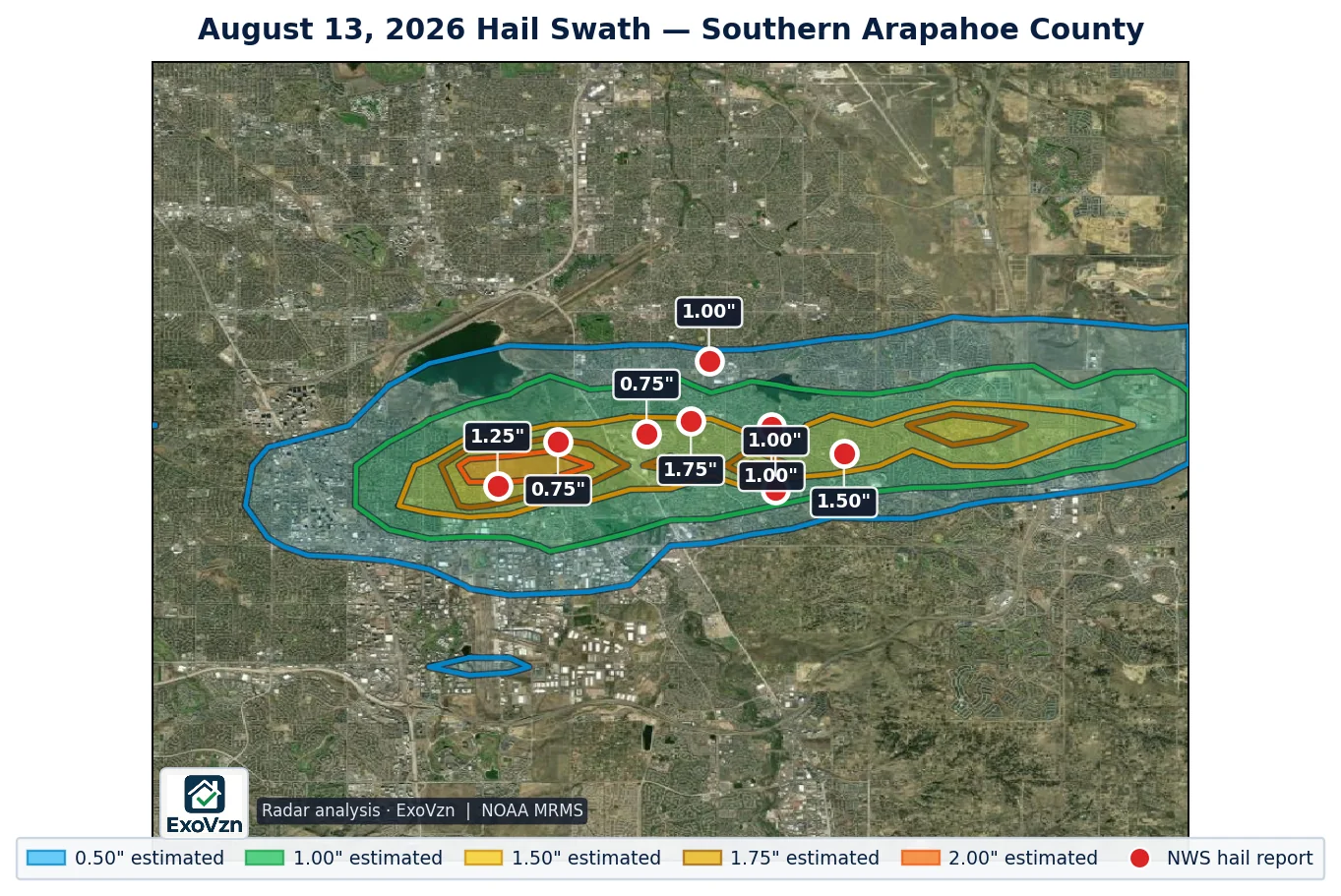
What happened on August 13
NWS Denver/Boulder issued a severe thunderstorm warning at 3:58 PM, tagged for 1.50" hail and 60 mph wind. The first hail report came in 9 minutes later, from a mile west-northwest of Foxfield at 4:07 PM. Centennial reported at 4:10 PM. Foxfield’s 1.50 inch stones were measured at 4:15 PM. Arapahoe Park picked up reports at 4:19, 4:25 and 4:30 PM — the last one arriving the same minute the warning expired.
Tracking the storm through radar shows it moving almost due east at about 15 mph, with almost no northward drift. That matches the order the reports came in: Foxfield, then Centennial, then Arapahoe Park.
What makes this storm worth paying attention to is how tight it was. The band of 1.50 inch or larger hail measured roughly 9.1 miles long and only 1.4 miles wide. Inside the south metro, about 21.9 square miles took an inch or more, and only about 2.6 square miles took the largest sizes. If your neighbor two streets over says their roof looks fine, that genuinely tells you nothing about yours.
Not sure whether your roof was in it? We'll come look, free.
Schedule My Free Inspectionor call (720) 771-8921
Every hail report, by location and time
These are National Weather Service Local Storm Reports for the afternoon. Where a report is marked measured, an observer put a ruler or gauge on the stone. Where it is marked reported, an observer selected a size category — golf ball, quarter — which is how most public reports arrive.
| Location | Size | Time | Source | Basis |
|---|---|---|---|---|
| 2 miles west of Arapahoe Park | 1.75" | 4:25 PM | Public | reported |
| 2 miles NNW of Foxfield | 1.50" | 4:15 PM | CoCoRaHS observer | measured |
| 2 miles NNW of Foxfield | 1.50" | 4:15 PM | Trained spotter | measured |
| Centennial | 1.25" | 4:10 PM | Public | reported |
| 2 miles west of Arapahoe Park | 1.00" | 4:19 PM | Trained spotter | measured |
| 1 mile west of Arapahoe Park | 1.00" | 4:30 PM | Public | reported |
| 1 mile WNW of Foxfield | 1.00" | 4:07 PM | Broadcast media | reported |
| 3 miles west of Arapahoe Park | 0.75" | 4:19 PM | Public | reported |
| 1 mile NE of Centennial | 0.75" | 4:10 PM | Public | reported |
By city: four reports around Arapahoe Park, three around Foxfield, and two in Centennial. The two Foxfield reports at 1.50 inches came from different observers at the same time — a CoCoRaHS volunteer and a trained spotter — which is about as solid as ground confirmation gets.
The observers also described what they saw. A trained spotter west of Arapahoe Park reported dents on metal roof vents and a significant amount of leaves stripped from trees. A CoCoRaHS observer southeast of Aurora logged six minutes of hail, hard white ice, with shredded leaves and dents in cars. Near Foxfield, broadcast media reported hail accumulating up to three inches deep in yards, with drifts of two to three feet.
One detail from that CoCoRaHS report deserves attention: the average stone was half an inch even where the maximum was 1.50 inches. A hail report always names the largest stone found, not what fell across the whole roof.
How big was the hail, and why one inch matters
The damage mechanism is kinetic energy, and it scales brutally with size. A one-inch stone reaches about 41 mph falling and lands with roughly 1.3 joules of energy. A 1.75 inch stone reaches about 65 mph and lands with roughly 16 joules — about thirteen times the impact energy. At Denver elevation, thinner air adds another 8 to 10 percent to fall speed.
Published impact studies put the onset of functional damage at:
- About 1.00 inch for standard three-tab asphalt shingles
- About 1.25 inches for architectural or laminated shingles
- About 2.00 inches for Class 4 impact-rated products
Seven of the nine reports on August 13 were at or above one inch. Damage starts as granule displacement, then progresses to bruising — a fracture of the fiberglass mat underneath a surface that still looks intact. That is why a hail-damaged roof so often looks perfectly normal from the driveway.
Age matters too. These thresholds fall as asphalt oxidizes and hardens with time. Research published by the Insurance Institute for Business & Home Safety in 2025 found that shingles previously exposed to weathering and sub-severe hail were roughly ten times more susceptible to damage in a later severe event. An older roof that has taken smaller hail before is not starting from zero.
Why this storm, and why only here
The setup that afternoon was, on paper, marginal. The Storm Prediction Center never forecast more than a Marginal Risk — level 1 of 5 — with a 5 percent hail probability, and held that through every issuance.
Model analysis over the Centennial and Foxfield area showed strong instability: about 2,966 J/kg of most-unstable CAPE and an unusually moist air mass for the High Plains. But wind shear was only about 22.5 knots. Shear is what tilts a storm so its updraft and its rain-cooled downdraft occupy different space, letting it survive for hours. Twenty-two knots is weak — enough for a brief, intense pulse storm, not an organized supercell.
It was also warm aloft, with a high freezing level. That means hailstones fall through a deep layer of above-freezing air and smaller stones melt before they land. Only the single strongest updraft core delivered stones intact to the ground.
The result is exactly what the reports show: one violent burst over a few square miles, then nothing. Radar put the storm’s probability of severe hail at 88.4 percent at its peak, with high reflectivity well above the freezing level — the signature of large ice being held aloft. Eastern Arapahoe County, a few miles further on, saw a radar-estimated maximum of about a third of an inch.
The wind reports were a different storm
Colorado logged eight damaging wind reports that day, topping out at 71 mph northeast of Severance. It would be easy to describe this as one big statewide storm. It was not.
| Location | Gust | Time | Source |
|---|---|---|---|
| 2 miles NE of Severance | 71 mph | 8:19 PM | Mesonet |
| 11 miles NNW of Simla | 67 mph | 4:31 PM | Public |
| 9 miles NNW of Simla | 64 mph | 4:28 PM | Public |
| 1 mile east of Limon | 62 mph | 6:06 PM | ASOS |
| 8 miles south of Lindon | 61 mph | 5:51 PM | Public |
| 7 miles WNW of Simla | 60 mph | 4:30 PM | Mesonet |
| 2 miles north of Bristol | 60 mph | 5:00 PM | Amateur radio |
| Firstview | 59 mph | 7:51 PM | Mesonet |
The Simla gusts were recorded at 4:28, 4:30 and 4:31 PM — the same minutes as the tail end of the metro hail, about 60 miles east-southeast. One storm cannot be in both places at once. Radar showed no hail at all at Severance or Firstview, where the strongest gusts were measured. Those were wind-only events, one of them 70 miles north and four hours later.
If you are in the south metro, the hail is the part that concerns your roof.
Nine reports don't map a storm. We'll check your specific address.
Schedule My Free Inspectionor call (720) 771-8921
Radar-estimated hail is not measured hail
You will see bigger numbers than 1.75 inches quoted for this storm. Radar hail algorithms output a deliberate high-end estimate of what may exist inside the storm cloud, not a measurement of what landed on your roof. For this storm the peak radar estimate anywhere in the metro was about 2.28 inches, against a largest ground report of 1.75 inches. That gap is normal and expected.
Radar is genuinely useful for one thing: it shows the shape of the swath between the handful of places where somebody happened to be standing. Nine reports do not map a storm — radar fills the gaps. Treat the swath as the search area and the ground reports as the confirmed observations. If a contractor tells you radar showed three-inch hail at your address, ask whether anyone measured it.
What to do next
- Check from the ground, not the roof. Walking a hail-struck roof is how people get hurt, and fresh foot traffic can mark shingles in ways that complicate an inspection later.
- Look at your gutters and downspout outlets. Granules washing off in quantity is the most common early sign.
- Check soft metal. Roof vents, gutters, flashing, the mailbox, patio furniture, AC condenser fins. Dents in soft metal are the reliable tell, because they date the storm — and observers in this storm specifically reported dented vents and dented cars.
- Photograph what you find, with your phone. Phone photos carry a timestamp in their metadata. Do not edit them.
- Get an inspection before the season turns. Bruised shingles shed granules over the following months. Damage that is subtle in August is often obvious — and leaking — by winter.
A word about the trucks that show up after a storm
A storm like this brings out-of-state crews into the neighborhood within days. Some are fine. Many are not, and Colorado homeowners have been burned enough times that the state wrote rules about it.
- A residential roofing contractor cannot pay, waive or rebate your insurance deductible in Colorado (C.R.S. 6-22-105). Anyone offering to is proposing something the statute forbids.
- Your contract must be in writing with the scope and cost stated (C.R.S. 6-22-103).
- If your insurer denies the claim in whole or part, you may rescind within 72 hours of that written denial and get your payments back (C.R.S. 6-22-104).
- Colorado has no statewide roofing license. Licenses are issued by the city or county pulling your permit — ask which one, and ask for insurance certificates from the insurer, not a copy from the contractor.
Ask any contractor where their office is and how long they will be in Colorado after this roof is done. The answer tells you most of what you need to know.
Frequently asked questions
Was there hail in Centennial on August 13, 2026?
Yes. The National Weather Service logged two hail reports in Centennial that afternoon — 1.25 inch hail at 4:10 PM and 0.75 inch hail one mile northeast at the same time. A severe thunderstorm warning covering Centennial was in effect from 3:58 PM.
How big was the hail on August 13, 2026 in Arapahoe County?
The largest report was golf-ball size, 1.75 inches, two miles west of Arapahoe Park at 4:25 PM. Foxfield had 1.50 inch hail measured at 4:15 PM by two independent observers — a CoCoRaHS volunteer and a trained spotter. Nine hail reports came in across the county in total.
What time did the hail hit the south Denver metro?
Every confirmed hail report landed between 4:07 PM and 4:30 PM MDT — a 23-minute window. The storm tracked almost due east at about 15 mph, moving from Foxfield through Centennial to Arapahoe Park.
How wide was the August 13 hail swath?
Very narrow. Radar analysis puts the band of 1.50 inch or larger hail at roughly 9 miles long but only about 1.4 miles wide. A home a mile off that axis may have seen little more than heavy rain, which is why a neighbor's undamaged roof tells you nothing about yours.
Which Colorado towns were affected on August 13, 2026?
Hail was reported in Arapahoe Park, Foxfield and Centennial, all in Arapahoe County. Damaging wind was recorded separately on the eastern plains and in northern Colorado — Simla, Limon, Lindon, Firstview, Bristol and Severance, where a station clocked 71 mph. Radar showed no hail at the wind report locations; these were two different events.
Is 1.75 inch hail big enough to damage an asphalt roof?
Yes. A one-inch stone falls at roughly 41 mph and lands with about 1.3 joules of energy. A 1.75 inch stone falls at roughly 65 mph and lands with about 16 joules — about thirteen times the impact energy. Published thresholds put functional damage beginning near 1.00 inch for three-tab shingles and 1.25 inch for architectural shingles. Denver's elevation adds a further 8 to 10 percent to fall speed.
How do I know if my roof was damaged in the August 13 storm?
Usually you cannot tell from the ground. Look for granules collecting in gutters and at downspout outlets, and dents in soft metal — roof vents, gutters, mailboxes, AC condenser fins. Observers in this storm specifically reported dented metal roof vents and dented cars. Those soft-metal dents matter because they date the storm. An inspection confirms it either way.
Was a severe thunderstorm warning issued for this storm?
Yes. NWS Denver/Boulder issued a severe thunderstorm warning at 3:58 PM covering Centennial, Foxfield and Arapahoe Park, tagged for 1.50 inch hail and 60 mph wind, expiring at 4:30 PM. That was about nine minutes before the first hail report came in, and it expired the same minute as the last.
Red Hawk has been on Colorado roofs for years. We're not going anywhere.
Schedule My Free Inspectionor call (720) 771-8921
Storm figures are National Weather Service Local Storm Reports for Colorado, 12Z August 13 through 12Z August 14, 2026, retrieved from the Iowa Environmental Mesonet archive and de-duplicated. Radar swath analysis by ExoVzn, an independent forensic meteorology firm, using NOAA MRMS data. Atmospheric values are from HRRR model analysis. Impact-energy and damage-threshold figures are from published hail impact research (Heymsfield et al. 2014; Marshall et al. 2002; IBHS 2025). Storm reports and radar analysis indicate where hail occurred; only a physical inspection establishes whether a specific roof was damaged.